|
Home DH-Debate 3. Mesozoic 5. Pleistocene |
| 1. Introduction | 2. CO2 |
| 3. Albedo | 4. Sea Currents |
| 5. Cosmic Radiation | 6. Paleocene |
| 7. Eocene | 8. Oligocene |
| 9. Miocene | 10. Pliocene |
| 11. Literature |
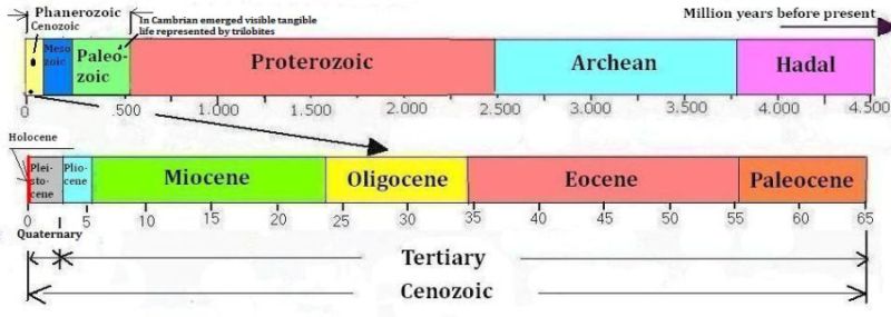
Phanerozoic is the part of Earth's history, where there has been visible tangible life. It is divided into Paleozoic, Mesozoic and Cenozoic, which are popularly called the Earth's antiquity, medieval and present.
Cenozoic is the age of mammals. Tertiary is the name of that part of the age when there were no humans. It is the earliest and longest-lasting part of Cenozoic. Tertiary means the third (age). The five periods of the Tertiary are Paleocene, Eocene, Oligocene, Miocene and Pliocene.
|
|
The geological periods - Hadean was the glowing inferno just after the Earth's creation. In Archean the first rocks were formed, an atmosphere of nitrogen, methane was formed and water condensed. In Proterozoic cyanobacteria produced oxygen that oxidized iron and methane, at the end of the period life emerged on the seabed. The entire period prior to Phanerozoic is often called the Precambrian, as it was previously believed that life originated in the Cambrian (earliest period of the Paleozoic) some 500 million years ago.
Phanerozoic - which denotes the period of life on earth - is divided in Paleozoic, Mesozoic and Cenozoic. Paleozoic was the period of early life, when plants, insects, fish, mollusks, corals, and many others living organisms were developed. Mesozoic was the era of the dinosaurs and Cenozoic is the age of mammals, which latter is further divided in Tertiary and Quaternary.
Tertiary denotes that part of the age of mammals when no humans existed. The climate of Tertiary is the subject of this article.
There are more and newer definitions of geological periods adopted at international geological congresses. Some divide the Tertiary into the periods Paleogene and Neogene, others let Quaternary start later in more accurate harmony with human appearance. However, the traditional period-division seems the author most suitable for a popular presentation.
|
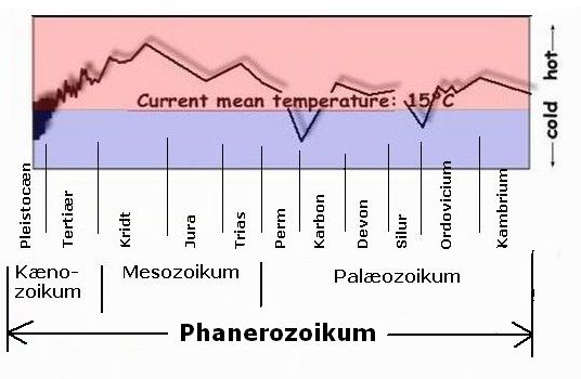
Top: The planet's average temperature as deviation from the temperature of today following Anton Uriarte - though added the geological periods. It is seen that the temperature has generally been slightly increasing until the Cretaceous period and then decreased down to the Pleistocene glacial periods. Furthermore, the curve has corresponding minima at the other two glacial periods in Phanerozoic, namely the Andean-Saharan ice age at the transition between Ordovician and Silurian and the Karoo Ice Age in the late Carboniferous and early Permian.
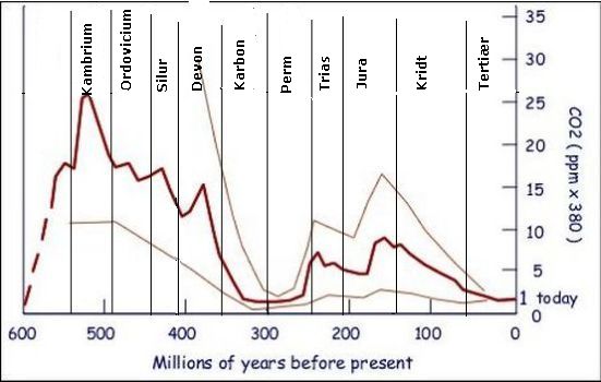
Bottom: The content of CO2 of the atmosphere in Phanerozoic following Robert Berner Yale University - though added the geological periods. The current CO2 content of the atmosphere is set to 1 (today). It appears that the CO2 content had a maximum in the Cambrian, and then declined with the exception of the minimum in the Carboniferous period. There are various reconstructions of the CO2 content in the atmosphere of the past, which are all different. But the trend is the same: in the vast majority the time, the concentration was much higher than in today's atmosphere.
There are indications that Earth's average temperature throughout Phanerozoic's 500 million years has had a slightly increasing trend up to the maximum of Cretaceous, however, interrupted by the two glacial periods, the Andean-Saharan and the Karoo. One can guess that this is due to the Sun's ever-increasing brightness.
Simultaneously with Earth's cooling through the Tertiary era, occurred a constant decrease in atmospheric concentration of CO2, as the concentration fell from at least 750 ppm down to today's 400 ppm.

|
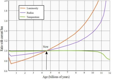
Top: Luminosity of the sun, the radius and the temperature, as a function of its age in billion years - following Ignasi Ribas: "The Sun and stars as the primary energy input in planetary atmospheres "- Proceedings of the International Astronomical Union, IAU Symposium.
Bottom: Variations in atmospheric oxygen content through Phanerozoic following
Robert Burner Yale University - though added the geological periods.
The sun is a star in the Hertzsprung-Russell diagram's main sequence. It will
remain in the main sequence around 11 billion years, during which time it will increase its luminous intensity three times in total. At the beginning of Tertiary 65 million years ago the sun had reached just over 99% of today's brightness, and as we know, since then it caught up.
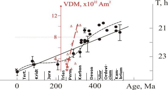
A research team from the "Geophysical Observatory" at "Institute of Physics of the Earth", Karelian RAS headed by V.V. Shcherbakova has compiled a database of
"magnetic torque values (VDM) of the Earth". On this basis, they have calculated Earth's orbital velocity through Phanerozoic - See link below. Points and triangles are direct measurements of respectively rotation and VDM values, the dotted black respectively red line are graphs aligned with points and triangles, and the straight black line is a statistical linear regression, which represents the Earth's rotational speed, i.e. diurnal length through Phanerozoic.
Following Robert Berner of Yale University, atmospheric oxygen percent from mid
of Triassic and until several million years into the Jurassic gradually represented a low for the entire Phanerozoic of about 15-17% before recovering to a maximum of about 27% in the very last part of Cretaceous. At the start of the Tertiary, the oxygen content in the atmosphere was about 25% and it has since fallen to today's 21%.
A team of researchers from the Russian "Institute of Physics of the Earth" in Karelia has set up a graph for the Earth's speed of revolution through Phanerozoic calculated on the basis of magnetic measurements. It can be seen that at the start of the Tertiary night and day lasted well 23.5 hours and - at the end of the period it lasted very close to today's 24 hours.
|
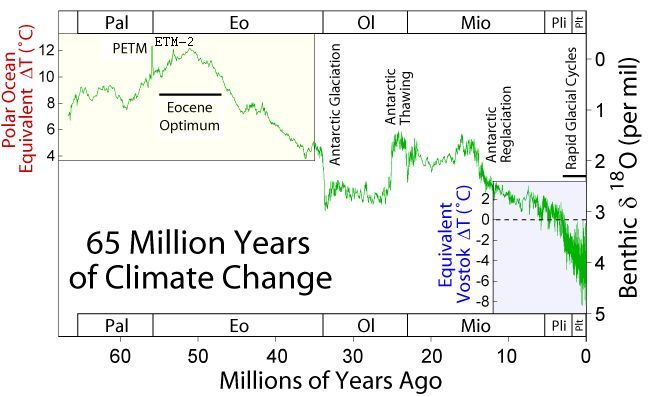
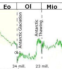
A reconstruction of the Earth's temperature through the Tertiary is taken from
Wikipedia
- Time passes by from left to right, and therefore, the present is on the right. Notice that the general trend is steadily cooling from the Cretaceous greenhouse temperatures to the freezer of the Pleistocene ice ages, however, overlaid by a shorter or longer periods of extreme cold or heat.
The graph is constructed on the basis of samples of deposits in the Arctic Ocean floor. The large scale to the right indicates the content of oxygen isotope O-18 in sediments. The ratio of oxygen-isotope O-16 and O-18 in the remains of shellfish indicates the temperature at the time the animal died. This is compared to analyzes of radioactive decay from the same layer, which indicates the time.
The letters above and below represent the geological periods. The five epochs of Tertiary are Pal for Paleocene, Eo for Eocene, Ol for Oligocene, Mio for Miocene and Pli for the Pliocene. Plt represents Pleistocene that is the ice age. Note the typical variations between real glacial and inter-glacial periods. Holocene, which is the present since the end of last glacial period, is a relatively short period of time that is not shown.
The scale to the left "Polar Ocean Equivalent delta-T (C)" shows the temperature as difference from present. It is supplemented with scale "Equivalent Vostok delta-T (C)" in the lower right corner, which shows results from ice core drilling at the Russian Vostok station in Antarctica, the scale indicate deviations from present temperature.
Tertiary lasted 63 million years. During this huge time span, Earth's average temperature steadily sank from Cretaceous greenhouse temperatures that were between 20 and 26 degrees down to the scary lows of the Pleistocene ice age that was an average of 5 degrees. We still live in a glacial period only we are fortunate enough that during the last 12.000 years the glaciers have temporarily withdrawn and given way to an interglacial period, which we call the Holocene. For comparison Earth's annual average temperature today is 14 degrees.
Throughout the Tertiary, which represents most of Cenozoic, the temperature was generally declining, however the graph is overlaid by several periods of particularly hot or cold climates, such as PETM, at the transition from
Paleocene to Eocene, the Eocene maximum, a sharp drop in temperature at start
of Oligocene, a heating period between Oligocene and Miocene, the Miocene maximum and the relatively warm climate of the Pliocene.
Earth's atmosphere today contains about 400 ppm CO2, which is 0.04% by volume%. It is 4 ten-thousand parts, that is a rather small part of the atmospheric air. Nevertheless, the vast majority of scientists, politicians and journalists with great passion has professed to the belief that a marginal change in this insignificant volume is the most important factor for the development of Earth's climate.
In light of this belief, many people assume that the high content of CO2 in the Cretaceous atmosphere was causing a greenhouse effect and hence the high temperatures and, consequently, the decreasing concentration of CO2 in the atmosphere caused the temperature to fall through the Tertiary period.
|
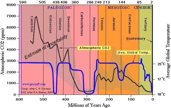
A comprehensive presentation of atmospheric CO2 and average global temperature during
Phanerozoic. - Time progresses from left to right. The vertical axis to the left is the CO2 concentration in the atmosphere in ppm. The vertical axis to the right side is the temperature in Celsius. Both have been decreasing in Cenozoic, however, in the earlier periods, the correlation between temperature and CO2 content is very poor, which implies that there is no cause-effect relation.
In hot periods, Earth's average temperature was about 25 degrees, to be compared with Earth's current average annual temperature that is about 14 degrees. Denmark's annual average temperature is about 8 degrees. (from http://www.scotese.com/)
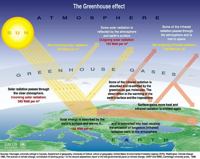
The theory that increasing CO2 content in the atmosphere is causing increased temperature says that CO2 is a greenhouse gas that allows for short-wave solar radiation to pass and thereby heat the Earth's surface, while it does not allow the long-wave heat radiation from the surface to escape into space. In this way, CO2 allows the heat to enter, but it does not allow it to escape again, much as the glass in the gardener's greenhouses.
As the atmospheric content of CO2 over the past about 50 million has been
steadily declining, while Earth's temperature also has been declining,
it is tempting to assume that this is about cause and effect.
However, when comparing the CO2 concentration and temperature of
Phanerozoic's earlier periods, one must admit that there is no eye-catching correlation.
|
Effect of greenhouse gases in the atmosphere - Most of the solar shortwave
radiation is converted to heat when it hits the Earth's surface. The thus heated soil, rocks and water emit long-wave thermal radiation. Some of this thermal radiation escape into space, but another part is reflected back to earth by greenhouse gases in the atmosphere.
CO2 is not the only gas with this attribute, methane is an even stronger
greenhouse gas, however, it becomes broken down chemically fairly quickly by atmospheric oxygen. Water vapor is also a greenhouse gas, it is not as strong as the other two, but there is much more of it.
Today, water vapor's contribution to the atmospheric greenhouse effect is limited to tropical and subtropical regions only. Because of the cold, the absolute humidity at higher latitudes is very low, for example, the water vapor content in the air during winter in Antarctica is about 0.00001 %, while moist areas around the Equator can have an absolute humidity of up to 4,0 %. In Jurassic and Cretaceous, the air at the poles was much warmer, and the absolute humidity was therefore also much higher than today, and consequently, water-vapor's contribution to greenhouse effect was also considerably higher.
We often hear that environmental alarmists say that the amount of greenhouse gases in the atmosphere has reached a "tipping point with no return" and that anthropogenic "global warming" threatens our civilization. But earlier in Earth's history - for example in Cretaceous - the CO2 content of the atmosphere has been far, far bigger than it is now, and nevertheless it dropped, little by little.
|
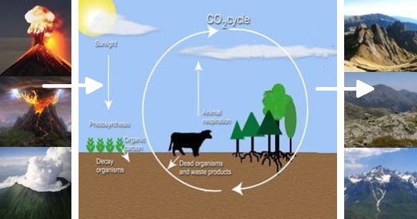
Earth's carbon circuit - Plants absorb carbon as CO2 by their photosynthesis. Some plants are eaten by animals and humans, who exhale CO2 to the atmosphere. When plants, animals and people die, they will rot, and most of the carbon content in their bodies will return to the atmosphere.
However, this important circuit is not completely closed. All Earth's CO2 originally come from volcanoes, and active volcanoes still add large amounts of CO2 to the atmosphere. In addition, the circuit has several leaks, the air's CO2 dissolves in rain and becomes acid rain, which reacts with barren rock in Earth's mountains, and the resulting chemical compounds in the form of carbonates are washed away by rivers and in the end left on the ocean floor, where they remain as sediments. Various biological decay form deposits and do not return to the carbon circuit.
The planet's temperature fell, because the CO2 content in the atmosphere decreased the climate alarmists say. It's a nice theory, but where did it go? That brings us to the carbon cycle.
Plants take up carbon as CO2 from the atmosphere through their photosynthesis. Some plants are eaten by animals and humans, who thereby take up carbon. Animals and humans exhale carbon into the atmosphere as CO2. When humans, animals and plants wither and die, they decay to CO2 and other compounds, thereby bringing carbon back into the atmosphere. Forest fires and other burnings also bring large amounts of carbon back to the atmosphere as CO2.
Some Mentos-sweets in a cola-light transform the dissolved CO2 into CO2-gas with high speed, creating an almost explosive foaming.
Some have figured out that the Earth's plants annually produce 150 giga-tonnes (nine zeros) organic carbon compounds with their photosynthesis, and a similar
amount is each year brought back to the atmosphere through decay, fires,
respiration and oxidation.
As we know from colas and sodas, large amounts of CO2 can be dissolved in water. One liter of cola contains more than two liters of CO2 at normal pressure and temperature. We also know that if we heat cola, CO2 will escape as bubbles, because more CO2 can be dissolved in cold water than in warm.
Thus, atmospheric CO2 is also dissolved in Earth's oceans. In cold periods they can contain more CO2 than in warm periods. This means that Earth's oceans act as a CO2 storage that absorbs CO2 during cold periods and releases it again in warm periods.
Together, these processes make up a stable cycle, which annually circulates 200
-300 Gigatons carbon around in different circuits. All life on Earth depends on this balance.

|
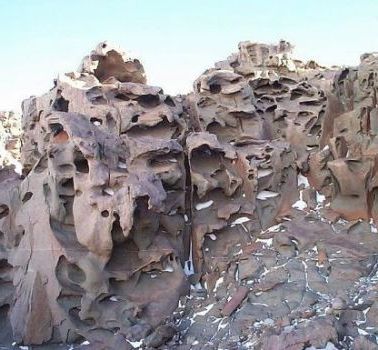
Left: Gargodyl of limestone which has guarded Notre Dame in Paris since
the Middle Ages. The surface is severely degraded by acid rain.
Right: Weathered rock at the Matterhorn in the Alps on the border between Switzerland and Italy. All rain on Earth contains CO2 and is therefore slightly acidic, and therefore all exposed rocks slowly degrade and the breakdown products will be washed away by the rivers.
However, the circuit does not close. CO2 is constantly being added to the
system, and there is also a leak, where CO2 will disappear and not be
recycled.
All CO2 in the atmosphere is originally from volcanoes, whose eruptions are
irregular and unpredictable. Only in recent times also humans have added CO2
to the atmosphere by burning fossil fuels, which also originally got their carbon from volcanoes.
When CO2-containing rain falls on bare mountains it will react chemically with rocks and form various carbonates that will be carried to the ocean floor by rivers. It is not very much CO2 per year, which in this way is leaking out of the carbon cycle, but for 65 million years it will anyway make a difference.
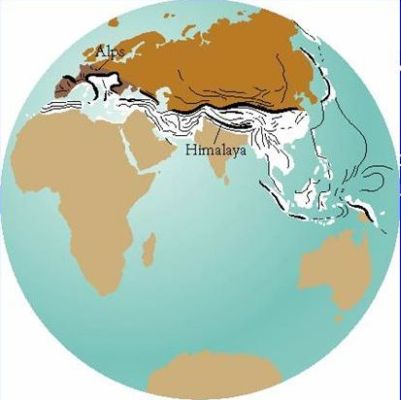
|
Top: Many of Earth's high mountains were created in Tertiary by remains of Gondwanaland which pressed against Eurasia. The dark brown is Eurasia and
the light brown are the remains of Gondwanaland. The black lines show the many
newly formed mountains.
Bottom: Monsoon rain upon Himalaya.

Grass grows over the tiles. If the garden owner does not take action, the tiles will be fully covered within maybe 10-15 years.
Most of Earth's major mountain ranges were formed during Tertiary. Only twenty million years ago the Indian subcontinent started to push against Asia thereby creating the Himalayas and the Tibetan Plateau. Twenty million years ago the clash between Africa and Europe created the Alps. The Andes Mountains of South America started a major build-up fifty million years ago. The Rocky Mountains were formed at the beginning of Tertiary.
In other words, precisely in Tertiary were formed vast areas of land with naked rocks that continuously were eroded by the slightly acidic rain, and thereby constantly leaked carbon out of the carbon-circuit. This explains why the CO2 content in the atmosphere fell during the Tertiary.
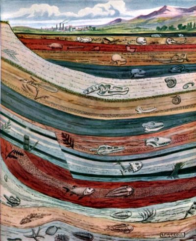
Geologic layers of the Earth's underground. Archaeologists and geologists must mostly dig down to find the past. All this material to dig through is created by processes, which represents output of the biosphere's carbon balance. Acid rain erodes rocks and photosynthesis and biological activity create organic decay, which to some extent does not return to the carbon cycle.
How can it really be that archaeologists and geologists always have to dig through various archaeological and geological "layers" to find the past? Where does all this material come from? It comes to a large extent from erosion and biological activity, which both processes consume CO2 from the atmosphere and take it out of the biosphere's carbon cycle.
In the long term, the carbon content of the biosphere is a balance between input and output. Active volcanoes add carbon to the biosphere in the form of CO2 into the atmosphere, and erosion of rocks and various organic decay removes CO2 from the biosphere. In periods of many active volcanoes, the CO2 content in the atmosphere has been big for example, in Cambrian and Cretaceous. Atmospheric CO2 content in Carboniferous was low due to the large output in terms of formation of coal sediments. In present times the CO2 content is also low, perhaps because of the large chemical degradation of naked mountainsides and little volcanic activity.
Some have calculated that if no CO2 is added at all, the atmosphere and the oceans will be emptied for CO2 over about 2.5 million years and all photosynthesis and thus all life will then cease.
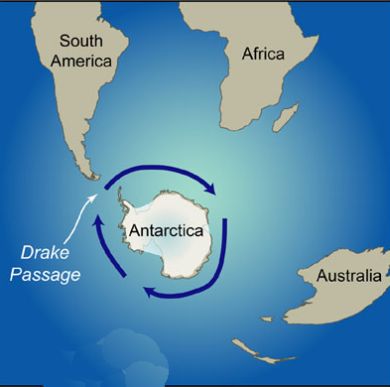
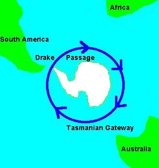
The Drake Passage.
When the Drake Passage opened between Antarctica and South America, and the Tasman Sea was formed; Antarctica became isolated from the rest of the earth by circumpolar ocean currents. Therefore, the continent could no longer exchange heat and cold with World's oceans and other continents. This was the reason why that inland ice was formed on the South Pole for the first time in Tertiary 34 million years ago.
Ice has a very high albedo, which means that such areas are very difficult
to heat, since most of the solar rays will be reflected back to space. The Antarctic ice's high albedo not only contributed to the continent's low temperature, but also to that Earth's total heat input from the Sun became less.
Some think that all the major mountain ranges and plateaus, which were formed
during the Tertiary era, especially the Himalayas, the Tibetan Plateau, the Alps and the Andes mountains, reflect more sunlight back to space than the forests, swamps and grasslands that existed there before the mountain uprising, because they have a higher albedo and more often are covered with ice and snow. In this way, Earth did not absorb so much of the sun's heat as before, which was a cause of the steadily decreasing temperature.
When you are standing well dressed on a cold windswept plateau of Tibet or Bolivia, you can probably get the idea that this part of the world does not receive as much solar energy as a beach on Hawaii or a jungle in Central Africa.
During Tertiary, Antarctica was cut off from South America by the formation of
The Drake Passage and also cut off from Tasmania and Australia by the formation of the Tasman Sea. Thereby, open sea was created all around
Antarctica, which allowed the formation of the strong current, the enormous
waves and raging storms south of Cape Horn that sailors have always feared.
The waves could now freely roll around the globe and be amplified for each time.
|
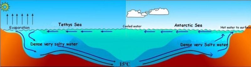
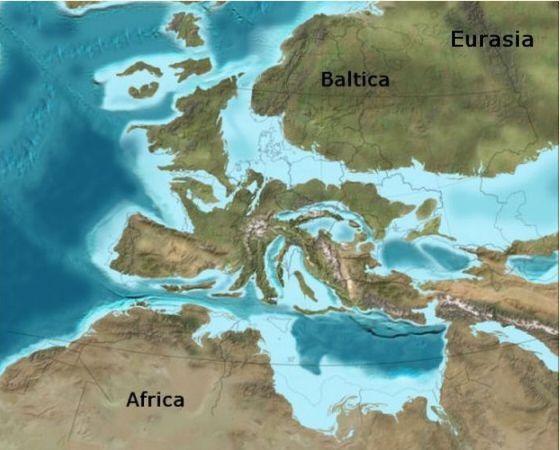
In Cretaceous and early Tertiary, the Tethys ocean was a huge shallow tropical
archipelago, where the water was significantly heated by the greenhouse climate of the time. Due to evaporation salinity and thus density increased, it sank to the bottom, and the warm salty water flowed towards Antarctica as a warm bottom current.
Thereby Antarctic was climatically cut off so that the continent could no longer exchange heat and cold with the rest of the globe. Thus began the cooling of Antarctica, and the first ice formed on this continent.
|
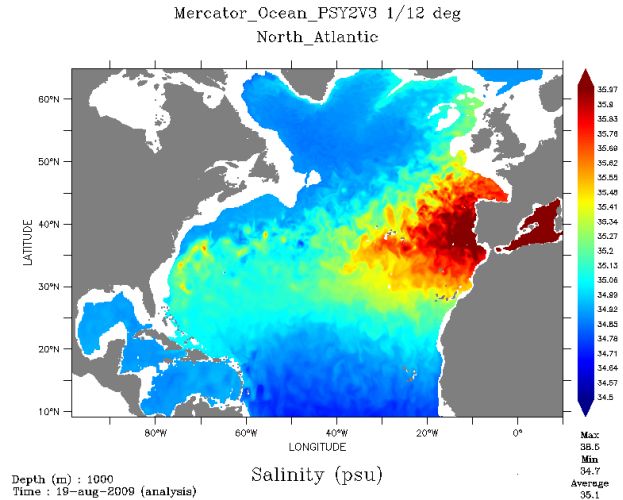
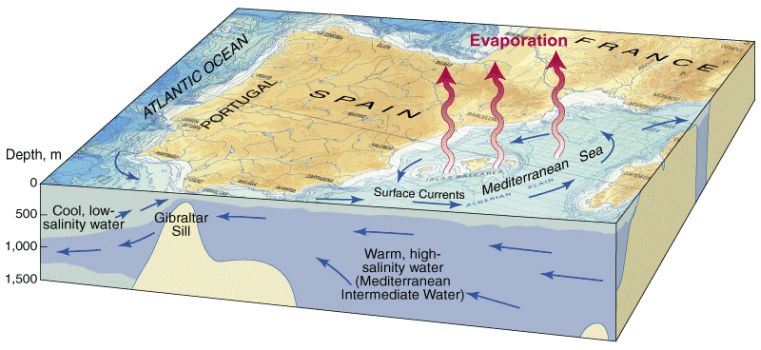
Still today there is a very high evaporation from the Mediterranean. More water evaporates than supplied from rain and rivers. The heavy saline water
sinks to the bottom, and as a warm salty bottom current it flows through Gibraltar and spread in the North Atlantic. The map shows salinity in 1000 m depth. - High salinity is marked in red.
In Cretaceous and early Tertiary Europe was an archipelago in the huge shallow tropical Tethys Sea. As in the Mediterranean today the evaporation was very high. Therefore, the salt concentration of the surface water increased, and the thus heavier heated water sank to the bottom and flowed as a warm bottom current to the colder waters near the South Pole. Here the hot water came up to the surface at the Antarctic coast, thus contributing to a relatively warm climate in that continent.
However, during Tertiary the Tethys Sea was reduced to the
Mediterranean, Black Sea etc. that became cut off from the World's oceans and therefore was no longer able to supply the hot bottom current to the Antarctic coast, and therefore started the cooling of this continent.
The Mediterranean is one of the remnants of the Tethys sea, and it has a very strong evaporation. This very day a hot salty bottom current is flowing out through the Strait of Gibraltar, while cold and less saline water flows in as a surface current.
|
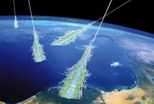
Top: Cosmic particles entering the Earth's atmosphere at high speed and energy. They ionize thousands of air molecules - including water vapor molecules, which then easily come together in clusters, called aerosols. Clouds are made up of aerosols.
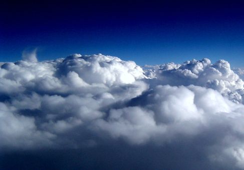
Bottom: Topside of clouds viewed from an airplane window - They are always very white, only from below some clouds can appear dark.
The Danish scientist Henrik Svensmark and his colleagues have demonstrated that data on cloud cover that have been taken down from satellites have a remarkable correlation with counts of cosmic radiation from space carried out in earth stations. He concluded that increased cosmic radiation is a cause of increased cloud cover on Earth and thus lower temperature, and vice versa, diminished cosmic radiation is the cause of reduced cloud cover and thus higher temperature. This discovery has given rise to a whole new theory of the causes of Earth's climate variations.
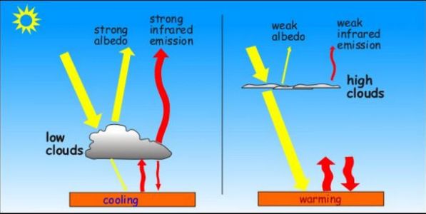
Low and high clouds work differently compared to the Sun's radiation of heat. Low clouds have a high albedo and reflect much sunlight back to space. High clouds, on the other hand, have a lower albedo and reflect little of the sun's rays back into space. Low clouds have a high infrared emission, which sends much heat into space, while high clouds only send little heat back into space as infrared radiation. Low clouds are dense allowing only a bit of the sunlight to penetrate them, while high clouds are thin and transparent.
The cosmic radiation comes from the Milky Way's supernovas. The intensity of the radiation which enters the atmosphere depends on the intensity of the
fundamental radiation, but also on the strength of sun's magnetic field since much of the cosmic radiation from outer space is deflected by this magnetic field.
Normally, we imagine that clouds are formed in the air by water vapor. But this is only partly true, as water vapor is a transparent gas. Clouds are formed by aerosols, which are clots of molecules in the air, among them water vapor.
When a cosmic particle enters the Earth's atmosphere with tremendous speed, it ionizes thousands of air molecules. The newly created ions will quickly get together to aerosols, thereby creating clouds.

A cloud goes for the sun - an experience we all know that illustrates the cooling effect of low clouds.
It has been shown that low cloud-cover, i.e. clouds below 3 km. altitude, are affected by cosmic radiation. Low-lying clouds cover more than a quarter of the Earth's surface in average and exert a strong cooling effect. (For clouds at higher altitudes, there is a complex interaction between cooling and heating).
The top sides of clouds are very white, as we often have seen it when we look out
the window of the airplane at 10 km. altitude. Clouds have a high albedo, and therefore they reflect a great part of the sunlight back to space - sunlight that otherwise would have warmed Earth surface.
Cloud cover has a significant cooling effect. We have often noticed when we are lying on the sand on the beach after a swim and enjoying the heat of the sun. Then a cloud covers the sun, and immediately we feel the heat disappear.
You could argue that nights with cloud cover are usually less cold than starry nights, because the clouds retain the heat. But the solar energy that initially is sent back to space during the day is lost forever, therefore the net effect of cloud cover is cooling.
This new theory about the causes of global climate-change challenges especially the widespread theory that variations in atmospheric content of greenhouse gases are the immediate cause of Earth's climate changes.
The movements of the solar system in the Milky Way. Both the Sun and the Milky Way itself inclusive the arms move clockwise, but the sun moves faster than the arms, as do most of the other stars. The stars in the arms are thus constantly replaced, but the arms remain.
One can imagine that when the Sun moves in a circular orbit around the center of gravity of the Milky Way, it is as if we are driving along on the motorway. Occasionally we encounter increased traffic, perhaps caused by truck columns, caravans and other cars, patiently staying behind these while waiting for an opportunity to get ahead again. After some time, we get through the increased traffic density and can again increase the speed. But if we could look back, we would see that the increased traffic density behind us still persists, only now with other cars.
Similarly, the Sun and other stars in their orbits around the center of the Milky Way form the Milky Way arms, which consist of stars that are constantly being replaced, which arms can also be observed in other galaxies. We can imagine that the increased gravity from other stars in an arm inhibits the speed of the individual stars through the Milky Way arm and thus ensures the existence of this.
The vertical axis is kilo-parsek; a parsec is 3.26 light-years. An orbit takes 230 million years, it is said (that is, the time from the Sun being in the Orion Spur, for example, until it is in the same arm again after one orbit). The star density and thus the risk of super novaes and consequent cosmic radiation, cloud cover and cooling are assumed to be greatest when crossing the arms of the Milky Way. From COSMOCLIMATOLOGY by Henrik Svensmark.
Henrik Svensmark's theory is very convincing to explain climate variations in relatively recent times, that is, since the end of last Ice Age. It may also explain why cold and warm periods have alternated during Phanerozoic. But that requires that we accept the theory that solar system does not have a permanent place in one of the Milky Way's arms, but revolves independently around the Milky Way center, a tour that takes 230 million years, says Martin Enghoff from DTU Space. Most of Milky Way stars do this, it is thought that the Milky Way arms are temporary formations, where stars are constantly replaced, a little like random traffic jams on the highway. Solar systems travel in space seems to be something like the moon in the classical science fiction series, "Moonbase Alpha".
The cosmic radiation is generated by super novas, which are exploding stars.
Therefore, the cosmic radiation must be most intense, when the Sun system passes Milky Way's arms, where the density of stars is highest. One can easily imagine that the strength of the radiation also must be associated with some statistical uncertainty, as it depends on how many, how big and how close supernovas that the solar system is exposed to on its passage through a galaxy-arm.
The strength of the cosmic radiation through the ages can be reconstructed from the amount of the isotope beryllium-10 in sediments.
|
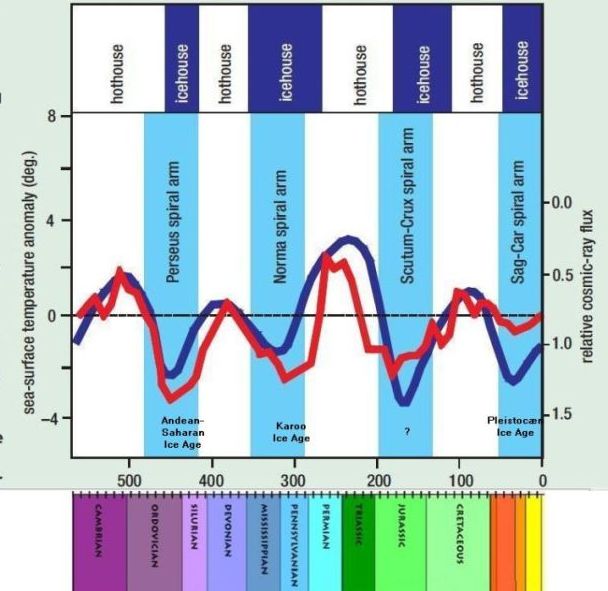
Cosmic radiation and temperature through Phanerozoic according to Nir Shaviv and Jan Veizer. The vertical axis on the left represents the temperature as deviations from present temperature. The vertical axis on the right shows the cosmic radiation as multiples of radiation today - today's radiation is set to 1. Note that the right scale is inverted so that strong radiation can be compared to low temperature. The red curve represents the temperature and the blue radiation. Temperature and cosmic radiation appear to have a very good
correlation. The horizontal axis represents time through Phanerozoic's more than 500 million years. Note that the Carboniferous is divided into "Missisipian" and "Pennsylvanian", that is an American custom, referring to different types of coal from the coal mines.
Phanerozoic's two first glacial periods - Andean-Saharan and Karoo - fit roughly with radiation maximum and with temperature minima. However, an ice age is lacking in the Jurassic, possibly at the transition between Jurassic and Cretaceous.
Nir Shaviv and Jan Veizer have proposed, what they think is Sun's
passages through the Milky Way's arms in this diagram, since they assume that in periods of high radiation and coldness the solar system has passed through a Galactic arm. It is not entirely satisfactory, that they thereby have assumed that the solar system's orbit around the Milky Way's center lasted all Phanerozoic's more than 500 million years. This is in contrast to both Henrik Svensmark himself and Martin Enghoff from DTU Space, who say that the tour lasts 230 million years. Also, it is not easy to understand how the red temperature curve can reach so far down in the Jurassic, where it precisely was very hot according to all other information.
From COSMOCLIMATOLOGY by Henrik Svensmark, however, added the geological
periods.
Nir Shaviv, an astrophysicist at the Hebrew University in Jerusalem, and the geologist Jan Veizer from Ruhr University have found a good correlation between the level of cosmic radiation and Earth's temperature during the last 500 mill. years. They also with less success try to compare temperature minima with the Sun system's passages of the Milky Way's arms, obviously assuming that one orbit lasts about 500 million years.
Nir Shaviv and Jan Veizer believe that the Perseus arm was passed at the transition between Ordovician and Silurian at the same time as the Andean-Saharan ice age. The Norma arm was passed in late Carboniferous almost simultaneously with the Karoo ice age. The Scutum-Crux arm was passed in Jurassic or perhaps the beginning of Cretaceous, they think - but there was no ice age! However, there are findings, which indicate that this period really was relatively cold; there are signs of freezing, drifting icebergs and perhaps small glaciers, but that is not an actual Ice Age. Shaviv and Veizer believe that the passage of the Sagittarius-Carina arm took place perhaps in the middle of the Tertiary Miocene period when the temperature dropped significantly, and the ice sheet in Antarctica was restored. Immediately thereafter the solar system passed into the Orion Spur arm, which was associated with the start of the current Pleistocene ice age.
Paleocene is the earliest period in Tertiary. It began with the K/T catastrophe
65 million before present, which destroyed all dinosaur species at one time, and
ended with the strange Paleocene-Eocene Thermal Maximum when the temperature
over a period of a few thousand years rose to at least 12 degrees above present temperature.
|
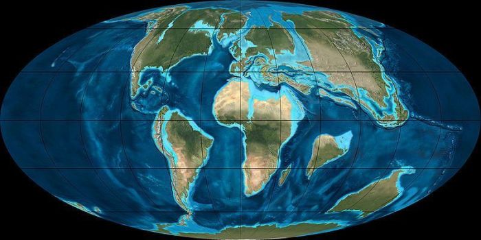
Reconstruction of the World in Paleocene. The Polar Sea was relatively isolated from the rest of the World's oceans. It was only accessible through three narrow straits. Namely the strait between Scandinavia and Greenland, the Bering Strait and a strait where now the West Siberian lowland is located. The Indian subcontinent was still moving against Asia. Europe was taking shape, but it was still an archipelago in the Tethys sea. North and South America were separate. South America still had connection to Antarctica. Map scotese.com.
The Paleocene climate was a continuation of the hot and humid greenhouse
climate of Cretaceous, the temperature was even increasing over the period. Earth's average temperature was maybe 18-20 degrees that should be compared with
the present annual average of 14 degrees.
Some writers think that the CO2 content in the Paleocene atmosphere was so high as 2000 ppm. Robert Berner of Yale University believes that it was well twice as high as today, about 700 ppm.
The oxygen content in the atmosphere was close to 25%, which can be compared to today's 21%. It is believed that insects were especially favored by the high oxygen content in the air.
|
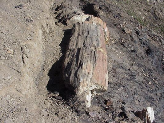
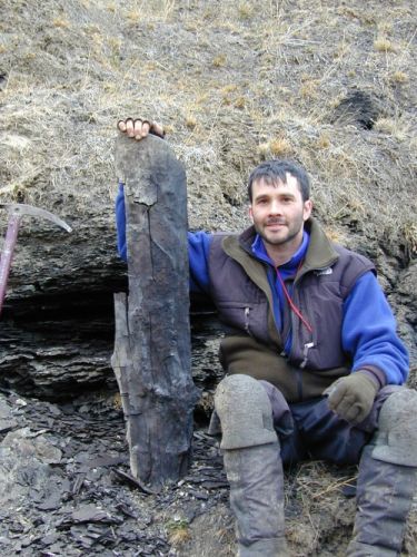
Top: Reconstruction of landscape in Paleocene.
Bottom: Petrified tree trunk from the Paleocene at Stenkul Fjord on Ellesmere Island - It is believed that it belongs to the species Metasequoia, which is a kind Redwood trees akin to the Californian giant trees - Photo Anne Jefferson.
Diurnal length was about 23.5 hours. The sun shone almost with today's
brightness.
|
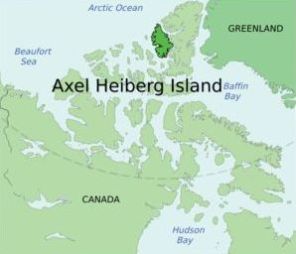
Left: Axel Heiberg Island.
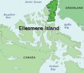
Right: Ellesmere Island.
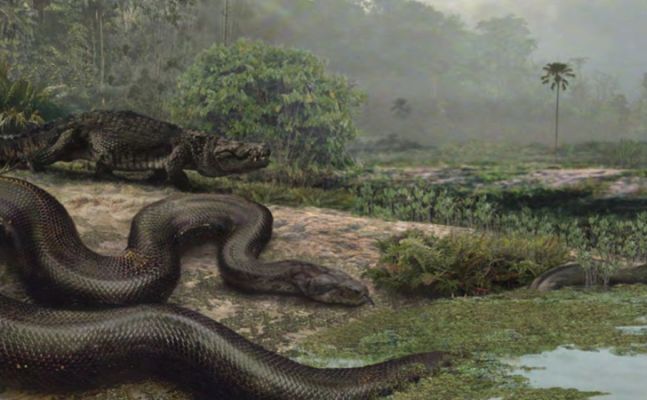
Across the Earth, the climate was hot and humid with subtropical vegetation in
Greenland and Patagonia. Along the coast of Greenland swam crocodiles, and in
Earth's tropical forests small rodent-like animals struggled against birds, reptiles and giant snakes on the ecological niches, which had become vacant after the demise of the dinosaurs. It was teeming with insects and flowering
plants.
In the far north, on Axel Heiberg Island and Ellesmere Island, located at the shores of the Arctic Ocean at same latitude as Thule in Greenland, many discoveries of fossilized leaves and logs from the Paleocene have been made.
Most of the Earth had a tropical climate, and there was a lot of rain and very little difference between summer and winter. Nearly whole Earth was covered with dense impenetrable virgin forests. There was no ice at the poles, and polar regions were covered with conifers and deciduous trees.

|
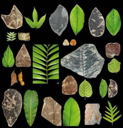
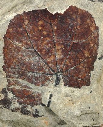
Top left: Fossilized leaves from Paleocene, found in the coal mine Cerrejon in
Colombia, compared to leaves from the modern jungle in Columbia. The gray ones are fossils from the coal mine, and the green are leaves from the modern jungle outside the mine. They are very similar.
Top right: Petrified leaf from Cerrejon, which is similar to the family Malvaceae, that is called mallow family.
Below: Mallow is a very common Danish weed.
In the coal mine Cerrejon in Colombia many leaves from the Paleocene jungle have been found. In the mine also a fossil of a giant snake has been found, which has been named Titanoboa, it is estimated to have been nearly 13 meters long and weighed more than one ton. Some scientists estimates from the shape of the leaves and the size of the snake Titanoboa that the temperature in the Paleocene Colombian jungle was about 30-32 degrees that should be compared to today's 27 degrees in the jungle surrounding the coal mine.
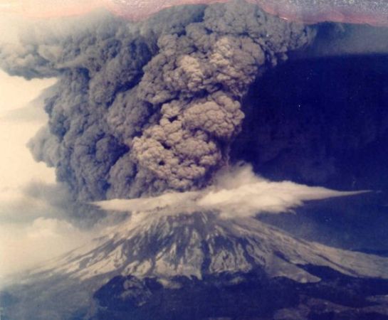
Volcano emitting large amounts of ash and gas, including huge quantities of CO2. - All CO2 present in the atmosphere can trace its origins back to volcanoes that have spewed it out from Earth's interior. Still, 95-99% of Earths carbon is left in Earth's interior that never has taken part in the carbon cycle. It's easy to assume that an increase in atmospheric CO2 content must be due to volcanism.
Paleocene ended dramatically 55 million years ago with the mysterious Paleocene-Eocene Thermal Maximum (PETM), which was a sudden global warming
that lasted about 80,000 years. Quite suddenly, seen with a geological eye,
it became unbearably hot on Earth. Average temperature rose up to 7 degrees in
relation to the greenhouse climate that prevailed in Paleocene already.
Most agree that atmospheric CO2 content was unusually high in this period and climate alarmists think that the heating have been caused by a greenhouse effect.
Volcanic activity is irregular and unpredictable. At the end of Paleocene
Greenland and North America moved away from Europe and opened the North Atlantic, a process that certainly must have been accompanied by extensive volcanism, that we still see in Iceland today. It could have emitted large amounts of CO2 from Earth's interior.
|
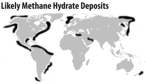
Left: Possible methane hydrate deposits in today's oceans. It has been suggested that offshore methane hydrate can be brought up and used as energy source - The black areas indicate possible methane hydrate deposits in today's oceans.
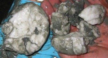
Right: Chunks of methane hydrate brought up from the seabed in the Gulf of Mexico 2002.
Some have deduced from the Karbon-12/karbon-13 isotopic ratio that a giant
meteor of the carbon type hit the Earth and spread its carbon all over the world, Carbon, which then was oxidized to CO2 by atmospheric oxygen. It suits
that atmospheric oxygen was decreasing in the period.
The oldest and still most popular hypothesis is that the carbon came from large deposits of methane hydrate, which was triggered from the seabed, perhaps because the Earth's temperature exceeded a critical value above which methane hydrate is no longer stable, or the triggering was caused by volcanic eruptions. The released methane bubbled up and was quickly oxidized to CO2 by atmospheric oxygen. Methane hydrate is a white solid stuff, which look like ice. It is made up of water molecules and methane. It is only stable at low temperatures and high pressure. It is found today in the World Oceans along the continental shelves and in the arctic tundra.
Some researchers have suggested that the global warming was due to peat fires throughout Earth that had produced CO2. It can be proved that the oxygen content of the atmosphere was quite high, and therefore, fires could start very easily. It is easy to imagine that there may have been fires in open coal deposits, with eternally burning coal that we today know from China, USA and Australia.
|
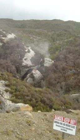
Top left: Burning coal mine near Denniston, New Zealand.
Top right: Burning Mountain in New South Wales, Australia. According to the Smithsonian Magazine, researchers estimate that it is the oldest known coal fire in the world, they believe that the mountain has burned in 6,000 years.
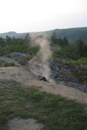
Below: Smoke and toxic gases rising from an underground coal fire in Centralia, Pennsylvania.
Even today, where the oxygen content of the atmosphere has dropped to 21%, thousands of underground coal mines and coal reserves all over the world are burning. Some have been ignited by humans in historical times, and others have burned for thousands of years. In China, coal fires are mentioned as early as 1,000 AC in a report by Li Dao Yuan exploring the Northwest China on behalf of Northern Song Dynasty (960-1280 AC). Marco Polo (1254-1324 AC) mentioned the "burning mountains along the Silk Road," which may have been ancient coal fires in Xinjiang. Researchers estimate that a burning coal deposit in New South Wales in Australia has been burning for 6,000 years.
Recent research has shown that PETM 55 million years ago was not quite unique. There have been other sudden warming periods. For example, scientists have found signs of a sudden minor warming period in the Eocene 53.7 million years ago, which has been named ETM-2.
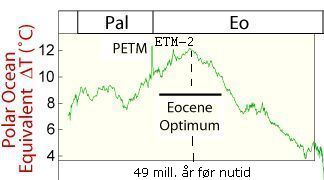
PETM, ETM-2 and the Eocene Thermal Maximum.
Eocene lasted from the end of the warming period PETM 55 million years before present and until the sudden temperature drop 34 million years before present, which marked the beginning of Oligocene when for the first time in the Cenozoic lasting ice was formed on Antarctica.
The Atlantic Ocean continued its expansion, and the distance between North America, Greenland and Europe was growing. This process is still going on today, accompanied by volcanic activity in Iceland, just as it in Eocene probably have been accompanied by extensive volcanic activity.
In late Eocene, the Indian subcontinent got contact with Asia and consequently began the creation of the Himalaya mountains and the Tibetan plateau. Also in
late Eocene South America became completely separated from Antarctica.
|
Reconstruction of landscape from the Eocene.
The prior Paleocene climate was hot, but in the early Eocene, it was even more unbearably hot and humid. After the brief and mysterious Paleocene-Eocene maximum (PETM) the temperature continued to rise to the Eocene Optimum about 25 degrees in global annual average temperature, which can be compared to today's global average temperature of 14 degrees and the Danish annual average temperature of 8 degrees.
The rising temperature curve from the start of the Eocene to the Eocene Optimum, 49 million years before present was briefly interrupted by yet another short-lived and sudden temperature rise, which lasted perhaps 100,000 years. It is called Elmo Event or ETM-2.
In the "Eocene Optimum" around 49 million. years before present, it was almost as hot as in the PETM. Then the temperature began to decline and it continued the next 50 million years down towards the Pleistocene ice ages, that we really are living in now.
Channel in the Somerset in the south west of England attacked by the fast-growing Azolla - Photo Hans Splinter.
Some American scientists believe that during the Eocene Optimum the Arctic Ocean was
filled up with a duckweed-like water plant, which is called Azolla. The so-called "Azolla Event" lasted approximately one million years. Some CO2-oriented researchers believe that this water-plant had a unique ability to absorb CO2, and when it sank to the bottom, carbon was removed from the atmosphere and from the carbon circuit. In this way, the plant reduced atmospheric CO2 significantly reducing the greenhouse effect and triggered thereby the temperature drop that should continue for the next 49 million years - these scientists say.
During Earth's history warm periods, "hothouses", have alternated with glacial periods, "Icehouses". The Eocene optimum was a culmination of the recent "hothouse" where the temperature at sea level near the poles sometimes was 14 -16 degrees higher than today, whereas the corresponding temperature difference in tropical waters was not nearly as dramatic. There was a more uniform climate all over Earth. This shows that the Eocene greenhouse climate represented a completely different weather system than the one we know today.
|
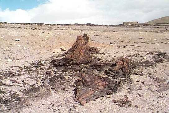
Top: Bill Hagopian holds a 54 million old piece of petrified wood from the Eocene
excavated on Ellesmere Island. - Photo Brian Schubert.
Below: A petrified piece of wood from the Eocene from Axel Heiberg Island.
40-50 million years ago, the Arctic islands, Axel Heiberg Island and Ellesmere Island, were covered by lush forests dominated by fast-growing redwood
trees, called Metasequoias, which are in the family of the redwood trees in present northern California.
Petrified stubs and logs on the islands witness of the Eocene forests in the past. The trees seemed to have adapted to the midnight sun and the Arctic winter with its three months in total darkness. They were about 30-40 meters high and grew close to each other.
In the hill-slopes scientists have found 28 layers of compressed fossil forests, interspersed with layers of silt or sand. 28 times, the forests succumbed, and the fallen tree trunks were covered with sand or silt.
This suggests that the trees grew on a large floodplain, perhaps something like the Mississippi Delta in southern Louisiana. Until the U.S. Army Corps of Engineers tamed the river and forced it to run in the current channels the Mississippi River periodically changed its course from East to West and back
over thousands of years. This created a very broad delta flood-plain and periodic floods that killed the trees, which fell in the water, where they
gradually became covered with silt or sand.
|
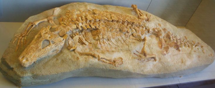
The crocodile-like Allognathosuchus that lived on Ellesmere Island in the
Eocene.
At Strathcona Fjord on Ellesmere Island have been found fossils from more than 40
various vertebrates from Eocene including a giant tortoises, a kind of alligator
called Allognathosuchus, a kind of rhinoceros called Brontotheres, the hippo-
like Coryphodon, a tapir called Thuliadanta and an early horse. Furthermore,
there have been found fossils from different predators that are not similar to any living species such as Creodonts, Mesonychid, a small swimming predator, and at least five various kinds of rodent.
Eocene ended abruptly with a sharp, almost vertical drop in the planet's temperature, maybe about 4 degrees, down to somewhat cooler climate of Oligocene. Thereby permanent ice was formed on Antarctica for the first time in the Cenozoic.
In Oligocene occurred a temporary drop in temperature compared to the steadily decreasing trend in whole Tertiary, the colder period lasted about 9 million years. Only in the last few million years of the Oligocene temperature rose again.
After the long-term and continuous temperature drop in the latter half of Eocene, the beginning of Oligocene for 34 million years ago was marked with a significant and sudden temperature drop of about 4-5 degrees. It began with a cold spell called Oi-1, which lasted perhaps one million years. After Oi-1 temperature rose again, but only 1-2 degrees and the climate remained relatively cool throughout most of Oligocene.
Oligocene started 34 million before present and lasted until 23 million years before present, a total of 11 million years.
The climate in the Oligocene was still warmer than today's. Earth's gradual cooling was favorable for the development of mammals.
|
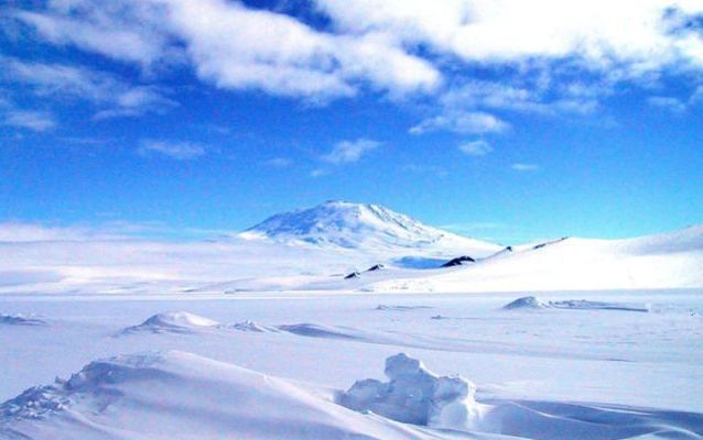
Left: Glacier in Antarctica with the volcano Mount Erebus in the background. The ice in Antarctica is dazzling white and has a higher albedo than the Greenland ice. The area of the Antarctic glaciers is bigger than Australia's area.
Right: The circumpolar current around Antarctica.
Many believe that the rather sudden drop in temperature in the early Oligocene
was due to that South America and Antarctica drifted apart and the Drake Passage
opened. Some time before Antarctica had already separated from Australia-Tasmania opening the Tasman Sea. This last event created the cold circumpolar current around
Antarctica, as we know it today. Waves could now freely roll around the World
and be reinforced for each lap.
Thereby Antarctica was climatically isolated, and the continent could no longer
exchange heat and cold with the rest of the Earth. Therefore, for the first time in Cenozoic was formed permanent ice on the South Pole. The ice in Antarctica is dazzling white and has therefore, a high albedo, which meant that a very large proportion of the Sun's rays now was reflected back to space, whereby the Earth's heat input became less than before, and the temperature drop was amplified.
Reconstruction of Europe in the Oligocene. The African and the Eurasian plate are pushing against each other, and Europe is starting to rise from the sea. The Tethys Sea has now been greatly diminished, and its connection to the world's oceans is rather restricted and therefore it is no longer able to provide a hot bottom stream of saline water to the shores of Antarctica. Map scotese.com
Some believe that the cause of the Oligocene temperature drop was even more
complex. They think that previously Antarctica had been heated by a hot bottom
stream of relatively salty water which flowed from the huge shallow tropical
Tethys Sea to the coasts of the southern continent, where it came to the surface and delivered its heat. However, in the early Oligocene Africa and Eurasia began
to close in on the Tethys Sea. The two huge tectonic plates pushed against
each other and Europe and the Middle East rose up slowly from the bottom of the sea. The Tethys sea became gradually reduced to the inland seas Mediterranean, the Black Sea, the Caspian Sea, the Persian Gulf and the Red Sea. The Tethys Sea became thus greatly reduced, and the remains had no longer effective connection to the World's oceans, then it could no longer deliver the hot bottoms stream headed for the southern polar regions.
It has been found that the temperature of the deep sea in Oligocene was less than 3 degrees that can be compared with the 12-15 degrees during the PETM and about the 2 degrees today. That shows that there was no longer any hot bottom stream bound for the southern polar regions. It is very likely that this dramatic temperature drop in the beginning of Oligocene marks a shift in the Earth's climate system, at least regarding the Southern Hemisphere, a shift from a weather system with high thermal exchange between Antarctica and the rest of the Earth, to a weather system with a climatically isolated Antarctica covered by a growing ice sheet.
Many northern forests were changed into tundra and further south other forest areas were turned into steppe. Oligocene saw the dawn of the first elephants with trunks, and the first primitive three-toed horses roaming the endless
steppe.
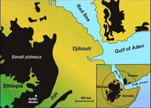
Volcanic basalt plateaus in Ethiopia and Somalia from the Oligocene 30 million
years ago. They are about the size of the whole of Spain.
In the northern hemisphere climate developed in some ways reverse. The Faroe Islands and Shetland sockets became separated and the North Atlantic continued to expand creating still broader connection between the Polar Sea and the oceans of the World thereby allowing a more efficient exchange of cold and warm water. Greenland remained ice-free and was first covered by ice millions of years later.
30 million years ago occurred a series of volcanic eruptions in the border area between Ethiopia and Somalia. An area the size of Spain was covered by a layer of lava up to two meters thick. This may have been the result of a number of smaller eruptions spread over many thousand years. Ash clouds from volcanoes can have contributed to significant temperature drops in Oligocene.
In the last few million years of Oligocene global temperatures rose again to a
level as before the Oi-1 - for reasons still not fully explained. The ice cap on Antarctica disappeared again.
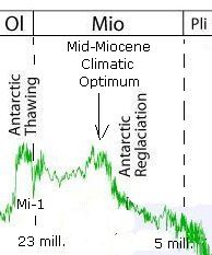
Mi-1, Mid-Miocene climatic Optimum and the drop in temperature in the last half of Miocene.
The transition from Oligocene to Miocene is marked by a sudden cold spell that
is called Mi-1. Some have found evidence of the formation of ice on Antarctica that caused the water level in the world's oceans to fall. Thereby shallow areas were exposed to wind and sun, which subjected them to severe erosion.
Analyses of sediments taken from the bottom of the Ross Sea near Antarctica indicates that the transition from Oligocene to Miocene was accompanied by cyclical changes in ice volume on Antarctica very similar to the cyclically recurring ice ages, which we know from the - geologically speaking - recently ended Pleistocene glaciations.
After the Mi-1 cold period, the temperature rose again and remained high throughout the first half of the Miocene. The ice cover on Antarctica melted away again, and the Arctic tundra areas were once again covered with pine forest.
|
World of the Miocene 20 million. years before present - Note that the Indian subcontinent is fully in place and seriously is pushing against the Eurasian plate thereby creating the Tibetan Plateau. The Drake Passage is open and there is still connection between the Atlantic and Pacific through the Panama Strait between North and South America. The Tethys Sea is now fully closed and reduced to a series of inland seas. Map from scotese.com.
Between 17 and 14.5 million years before present a new temperature maximum occurred called "Mid-Miocene Climatic Optimum". Fossils from both sea and land
indicate that the temperature was about 6 degrees higher than today's
temperatures.
But from the "Mid-Miocene Climatic Optimum" and throughout the rest of the period the temperature declined steadily down to about 1-2 degrees above present temperature. However, some researchers believe to have identified a significant cold spell during the period between 14.2 to 13.8 million years before present with a temperature drop of about 6-7 degrees.
Over the last few million years of the Miocene ice sheet were formed on Antarctica and for the first time on Greenland.
The formation of the Tibetan highlands happened gradually. Already at the end of Eocene, the Indian subcontinent got contact with the Eurasian plate, but only in Miocene started the press up of the Himalayas and the Tibetan Plateau
seriously.
|
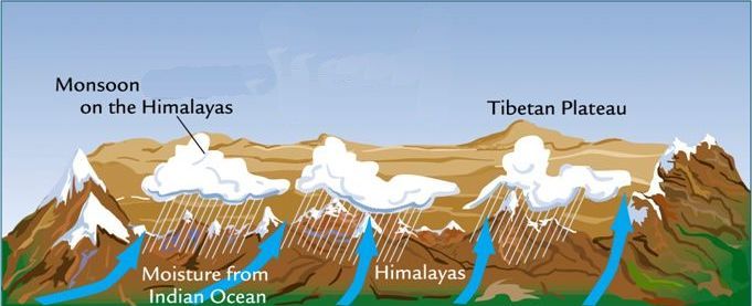
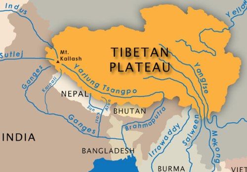
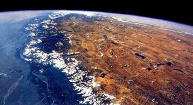
Top: The Tibetan Plateau with all the rivers that have their origin from there.
Bottom: Himalaya and part of Tibet seen from space.
The highlands bare rocks provide optimal opportunities for erosion. The
silicate rocks are broken down by acid rain, and carbon-containing erosion products are brought to the seabed by the rivers, thus leaking carbon out of the Earth's carbon cycle. The consequently reducing of CO2 content in the atmosphere is widely considered to have contributed to that Earth's climate, slowly - over millions of years - became increasingly colder.
|
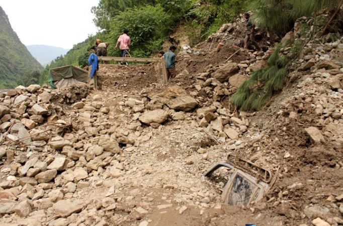
A road along a river in the Himalayas is washed away by heavy monsoon rain. The
nearby village had just one month before experienced another heavy storm with
destructive rain. Residents said that a hillside collapsed, and a huge amount of rocky debris tumbled down a wall of the local school with the result that the roof crashed, and 19 children were killed.
Himalaya and nearby mountain ranges are high and steep, and as they are near the
warm Indian Ocean, they are annually washed over by intense monsoon rain, which
is causing severe erosion. The major rivers Ganges, Indus, Brahmaputra, Yangtze and Mekong lead the carbon-containing corrosion products to the ocean floor. At the same time, the rivers lead a big quantity of other carbon-containing organic
substances into the sea in the form of fallen trees, grass, branches, leaves, twigs etc., which also are leaked out of the carbon cycle.
It has been calculated that these major rivers, that flow from the Tibetan Plateau, contain 25% of the total dissolved substances, which flows into the oceans and to great extent will be deposited on the seabed as sediments, where it will remain for millions of years.
It has also been estimated that in the course of only a few million years, these two processes have caused a significant decrease in the atmospheric content of CO2, which - following to the generally accepted theory - has contributed to a decline in the Earth's temperature.
The Tibetan Highland's area is about one million km2. This entire area was lifted to an average height of 5,000 m above sea level. The rocks and gravel of the plateau are brighter than the original forests and plains, that covered the area before the uplift, and thus it has a higher albedo than before. As the temperature of such heights is very low, a greater part of the surface is covered by ice and snow, which also increased albedo and thus further reduced the total heat input from the Sun.
Reconstruction of Europe in the mid-Miocene 13 million years before present. The Tethys Sea is greatly reduced and the Mediterranean Sea has a few narrow accesses to World's oceans. Map scotese.com.
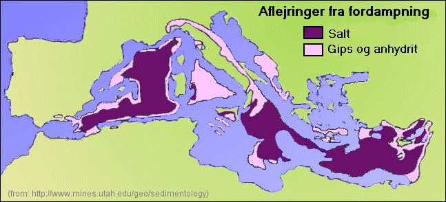
Another important event in late Miocene was the drying up of the Mediterranean. It has been shown that under the bottom of the Mediterranean are thick layers of salt and gypsum, which indicates that it repeatedly has been completely or partially dried up, as we today know it from the Dead Sea. The event is called "the Messinian Salinity Crisis".
At the beginning of Tertiary 65 million years ago, the areas which today constitutes southern Europe, North Africa and the Middle East, were part of a large shallow tropical archipelago, called the Tethys Sea.
During Tertiary, the African and Eurasian tectonic plates slowly closed around the Tethys sea, and finally, its connection to the World's oceans was completely cut off. As at the same time the pressure from the two plates pushing against each other caused the seabed to rise, the Tethys ocean was reduced to a number of smaller inland seas, which are the Mediterranean, the Black Sea, the Caspian Sea, the Persian Gulf and somewhat later the Red Sea.
|
Evaporation deposits in the Mediterranean. When the Messinian Salinity Crisis was at its Maximum in late Miocene, the Mediterranean was reduced to several separate salt lakes similar to the Dead Sea with surface levels several hundred meters below the World Ocean's surface level.
The Mediterranean was originally connected with the oceans of the World through various straits north and south of present Gibraltar. But in late Miocene, about 5-6 million years ago, these straits opened and closed cyclically, so that the Mediterranean alternately was an inland sea and alternately part of the Oceans of the World. It is reasonable to connect these cyclic opening and closing of the Gibraltar straits predecessors with the cyclical temperature fluctuations, which are evident in sediment analyzes from precisely end of Miocene.
At that time ice sheets have been formed on both Antarctica and Greenland, and it is easy to imagine that the cyclical temperature changes were related to cyclical changes in the size of ice sheets, as we know from the later Pleistocene ice ages. This means that when it was relatively cold, the glaciations grew, and the water level in the ocean fell, and therefore the Mediterranean was cut off from the world's oceans. When it again became warmer, part of the ice caps melted again, making global sea level rise, and the Mediterranean again got contact with the oceans and was again filled up.
|
Still today a hot bottom stream of water with high salt content flows out of the Mediterranean Sea through the Strait of Gibraltar and a cold surface current of less salty water flows into the Mediterranean Sea. The boundary layer between the two opposite currents was exploited by submarines during World War II to sneak unseen in and out of Mediterranean - From Blog Sobre Geociencia, see the link below.
The evaporation from the Mediterranean Sea is very large, even today. More water is evaporating from the surface than being fed by river and rain directly over the sea. If we imagine that the Strait of Gibraltar, the Suez Canal and the Dardanelles was closed; the Mediterranean would dry out in only 1,000 years
leaving a 70 m. thick layer of salt and gypsum on the bottom.
In 1970 the marine survey ship Glomar Challenger found thick layers of
evaporation products in the seabed on a water depth of 3 km. It is said that in
some places has been found layers of evaporation products, mostly salt and gypsum, which are 2-3 kilometers thick.
If one desiccation of the Mediterranean will create a salt layer at 70 m. then about 30-40 consecutive cycles of flooding and drying out are needed in order to create a layer of salt and gypsum of 2-3 kilometers. This shows that the Mediterranean has been dried out and filled again - not once but several times.
Pliocene is the most recent and shortest period of Tertiary. It began 5 million years before present and ended 2.6 million years before present.
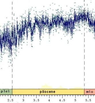
The relative frequency of the heavy oxygen isotope O-18 that indicates the temperature. From samples of shells of small shellfish from the Pliocene taken from the seabed. Time progresses from right to left.
The climate of Pliocene is generally believed to have been a bit warmer than today's. Maybe in beginning and in the middle of Pliocene, the temperature was about three degrees warmer than present. The climate was particularly mild at high latitudes, and some species of both plants and animals were found several hundred kilometers north of where their nearest related species exist today. It is believed that less ice sheet in Antarctica and Greenland caused the sea level to have been about 30 meters higher than in present days.
The general trend towards cooling during the Pliocene was associated with increased desiccation of some areas, where forests were replaced by grasslands. It was the case in East Africa, and thus the stage was set for the development of man. When the forest disappeared some monkeys climbed out of the trees, rose on its hind legs and looked for opportunities on the new grass steppe. Some believe that Australopithecus, or at least their ancestors, evolved here during the Pliocene.
The major tectonic event in the Pliocene was the creation of the Panama isthmus that connected South and North America by land.
So far, much of the warm Gulf Stream had escaped to the Pacific through the Strait between South and North America, and the Gulf Stream, which flowed towards Greenland and Northern Europe must have been considerably weaker than it is today. However, after the closure of the "Panama Strait" the whole Gulf Stream flowed to the north, and, ceteris paribus, it must have caused a milder climate along the coasts of the North Atlantic.
|
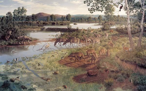
Artistic reconstruction of a landscape from the Pliocene.
But paradoxically enough permanent sea ice formed in the Arctic Ocean - precisely in Pliocene. This means that some of the ice did not melt during
summer, as the situation still is today.
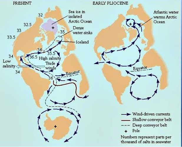
Some have explained this apparent paradox that before the "Panama Strait" was closed, the Gulf Stream contained less salty water, therefore, the water was lighter and was floating nearer the surface of the sea. Therefore, the warm current could easier pervade the whole of the Arctic Ocean and keep it free of ice, at least in summer.
Following the closure of the "Panama Strait", all the hot water from the Mexican
Golf floats towards north. This water has been exposed to excessive evaporation in the tropical waters, and therefore its salt concentration is relatively high and the water is therefore heavier than water containing less salt.
|
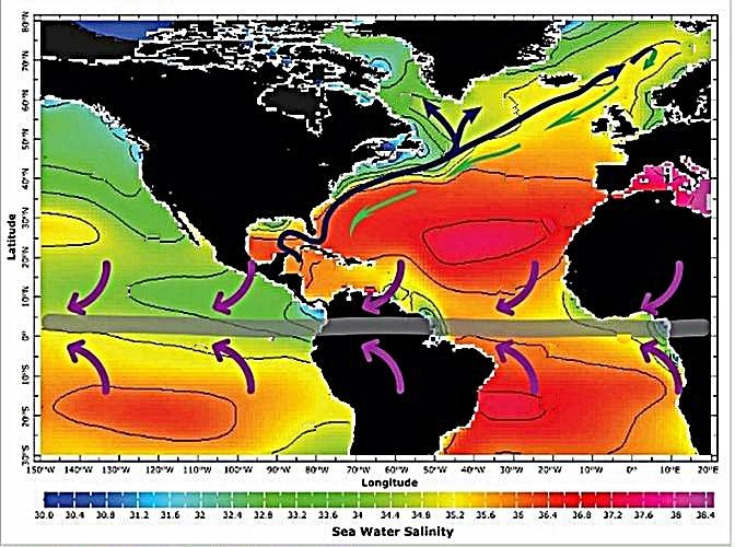
The salinity of surface waters in the Atlantic Ocean 2011. - The sun and the trade winds, that blow over the tropical Atlantic (purple arrows), cause a net loss
of fresh water (evaporation minus rain) from the Northeast Atlantic making
the waters very salty. A stream of very salty water from the Mediterranean Sea through Gibraltar also contributes to the salt content. When this warm and salty water from the tropical Atlantic flows north to the sub-polar regions of
North Atlantic with the Gulf Stream (dark blue arrows), the surface water cools down by evaporation, and the result is the creating of cold, salty surface water
which eventually become heavy enough to sink to the bottom in the area south of Greenland and in the Norwegian Sea. Thereby the North Atlantic Deep Water (NADW) is created. This NADW then flows south along the bottom of the Atlantic (green arrows). This circulation of northward-flowing surface water and southward flowing deep-Water is what oceanographers call the "Atlantic Meridional Over Turning Circulation" (AMOC). One can now realize that if the Gold stream had been less salty, it could possibly have penetrated more of the Polar ocean.
However, the hot saline water is barely light enough to stay in the surface, while it flows to the north. As soon as it becomes cooled down in the waters around Greenland, Iceland and northern Norway, its density will increase, it will be too heavy, sink to the bottom and begin its journey back to the tropical waters as a cold bottom current. And therefore when today's warm Gulf Stream does not go far enough to
penetrate the Arctic Ocean and keep it free of ice in summer, it can be because its salinity is too high.
In modern times one can observe variations in the extent of sea ice in the Arctic Ocean. For the time it seems to be receding. It is easy to attribute this to global warming, that is ice which melts. But it may very well be that
changes in the Gulf Stream's flow, salinity or temperature is just as important.
|
Ocean currents in the Atlantic and Arctic Ocean in present days and early Pliocene - Some believe that in Early Pliocene, while the Strait of Panama was still open, the Gulf Stream was less salty. Therefore, the hot water could have been lighter with more tendency to stay in the surface and thus more easily penetrate the Arctic Ocean and keep it free of ice. It is believed that a portion of the warmest, salty water escaped through the strait, and the resulting current towards North was therefore less salt and did not sink to the bottom so early.
One must also assume that the closure of the Panama Strait has contributed to the built up of the Greenland ice sheet and also during ice ages to the Scandinavian and North American ice sheets. It may sound paradoxical that an increased flow of hot water to the north is the cause of increased ice formation. But we must think that formation of ice sheets require a lot of precipitation in form of snow, and the Gulf Stream is precisely the cause of a lot of precipitation, as we know it from the rainy climate on the British Isles and West Norway. When the current streams further north it is still a cause of precipitation but in the form of snow. Eastern Siberia is even colder than Greenland, but there is no ice sheet - only frozen tundra, because there is very little precipitation.
The climate of the Pliocene was characterized by increasing cyclic variations between hot and cold weather, which predicted the coming interaction between ice ages and interglacial periods.
|
The Messinian Salinity Crisis (1/3) - Salt all over the Mediterranean Earth Science Blog - Blog sobre Geociencia. Retos Terricolas. Earth's Climate History (Kindle Edition) by Anton Uriarte. |
| To top |