|
Home DH-Debate 2. Paleozoic 4. Tertiary |
| 1. Introduction | 2. Triassic |
| 3. Jurassic | 4. Cretaceous |
| 5. Literature |
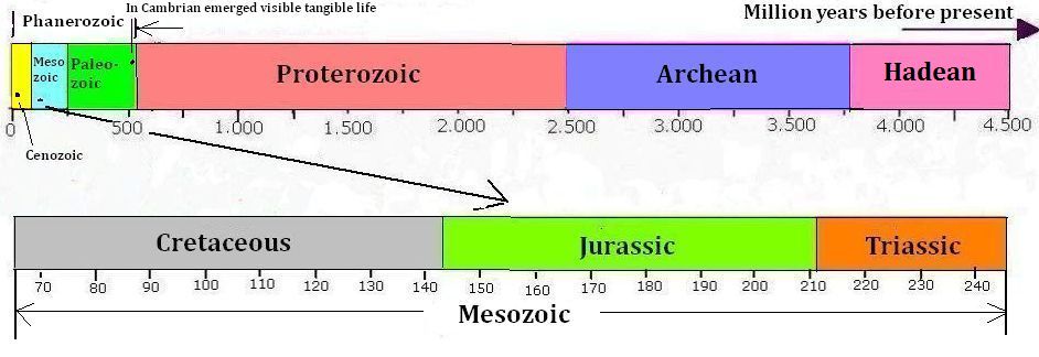
Phanerozoikum is the name of the part of Earth's history where there was visible tangible life. It is divided into Paleozoic, Mesozoic and Cenozoic, which are popularly called the Earth's ancient, medieval and present.
Mesozoic was the period of the dinosaurs. The period is further divided into Triassic, Jurassic and Cretaceous.
Start of Mesozoic with the beginning of Triassic was characterized by the harsh and dry continental climate of the gigantic Pangaea continent. Pangaea's split up in the following Jurassic period paved the way for a hot and humid greenhouse climate with little temperature difference between low and high latitudes. The temperature in Cretaceous was even higher, and most of the world was most likely covered with damp forests.
|
|
The surface of the Hadean Earth was a glowing chaos, characterized by intense radioactivity and an atmosphere of toxic gases. In Archean Earth's surface was solidified, the atmosphere consisted of nitrogen and methane, and the first cyano-bacteria occurred. In the Proterozoic methane and iron was oxidized and an atmosphere with oxygen was formed.
Phanerozoic represents the part of Earth's history, where visible tangible life existed, from the appearance of the trilobites in early Cambrian until the emergence of humans and historical time.
The Phanerozoic is divided in Paleozoic, Mesozoic and Cenozoic that can be called Earth's antiquity, medieval and modern times.
Paleozoic was the period of early life where plants, insects, fish, mollusks, corals and many more living organisms developed. Mesozoic was the era of the dinosaurs and is described in this article, and Cenozoic is the age of mammals.

|
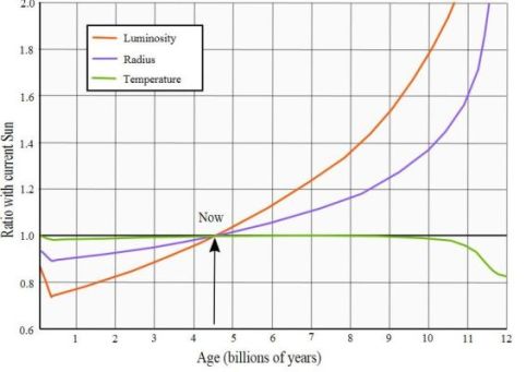
Top: Sun's brightness, radius and temperature, as a function of age in
Billions of years - after Ignasi Ribas: "The Sun and stars as the primary energy input in planetary atmospheres" - Proceedings of the International Astronomical Union, IAU Symposium.
Bottom: Atmospheric oxygen content through Phanerozoic by Robert Burner Yale University - added the geological periods. It seems that at the end of Proterozoic there has been a significant amount of oxygen in the atmosphere.
Sun is a fairly average yellow dwarf star in the Hertzsprung-Russell diagram's main sequence. It will remain in this sequence for about 11 billion years, in that time it will increase its brightness three times. Start of Mesozoic happened for about 250 million years ago, and the sun had then had a brightness of more than 97% of its present. By the end of Mesozoic 65 million years ago Sun reached just over 99% of today's brightness.
Following Robert Berner of Yale University, the atmospheric oxygen content has fluctuated between 15 and 35% during Phanerozoic.
From the mid-Triassic and some million years into the Jurassic, the atmospheric oxygen percentage sunk to a low point for the entire Phanerozoic of about 15-17% for thereafter to increase again to a maximum of about 27% at the transition from the Cretaceous to Tertiary that is the beginning of Cenozoic.
|
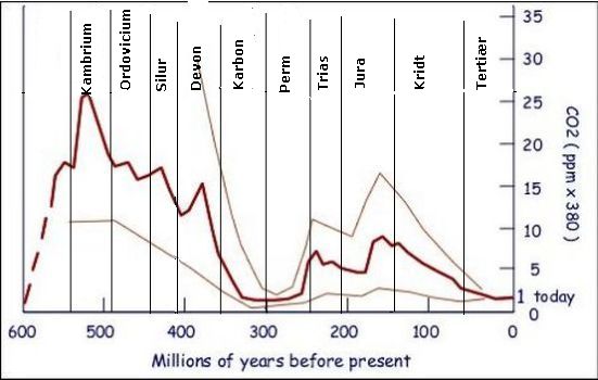
Top: Atmospheric content of CO2 during Phanerozoic following Robert Berner Yale University. It had a maximum in the Cambrian, and then it declined with the exception of the minimum in Carboniferous time. There are several reconstructions of atmospheric CO2 content of the past, which are all different. But the trend is the same: in most of the time, the concentration was much higher than in today's atmosphere.
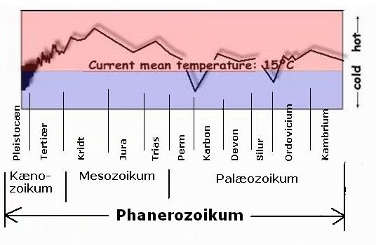
Bottom: The planet's average temperatures following Anton Uriarte - but added the geological periods. Temperature generally increased slightly until the middle of the Cretaceous period, after which it declined towards the Pleistocene ice ages. Additionally, the curve has a similar minimum at the other two ice ages in Phanerozoic, namely the Andean Saharan at the transition between Ordovician and Silurian, and the Karoo Ice Age in late Carboniferous and early Permian.
Throughout the Mesozoic, the content of CO2 in the atmosphere was considerably lower than in Paleozoic, that is between two and nine times as high as in today's atmosphere.
Scientists have calculated past temperatures from analysis of sediments from the bottom of the Arctic Ocean, using the fact that the quantity of certain oxygen isotopes depends on the temperature when the sediment was formed. During far most of Phanerozoic the planet's temperature was significantly higher than in modern times. Only during ice ages temperature was lower. Apart from these glacial minima, temperatures during the whole period have increased slightly until the Cretaceous maximum, a process that may be attributed to the Sun's increasing brightness.
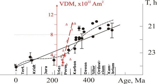
Length of day and night during Phanerozoic - A research team from the "Geophysical Observatory" at "Institute of Physics of the Earth", Karelian RAS headed by VV Shecherbakova, has calculated a database of "magnetic torque values" of the Earth (VDM). On this basis, they have calculated the Earth's orbital velocity through Phanerozoic - See link below. Points and triangles are direct measurements of respective rotation and VDM values, the dashed black respectively red line are regression-curves representing points and triangles, and the straight black line is a statistical linear regression representing the rotational speed of the earth, that is, diurnal length through Phanerozoic.
A team of scientists from the Russian "Institute of Physics of the Earth" in Karelia has calculated Earth's rotation speed through Phanerozoic based on magnetic measurements. It can be seen that at the start of Phanerozoic a day and a night lasted a little more than 21 hours and, of course, at the end of Phanerozoic it lasts 24 hours.
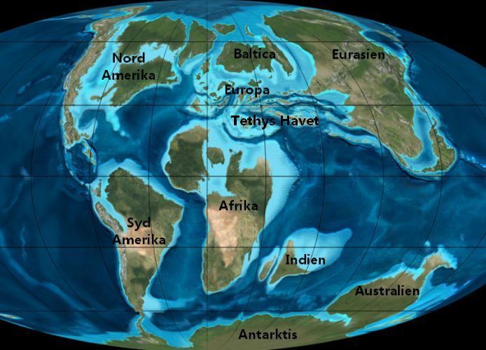
The supercontinent Pangaea was already formed in the Permian. In relatively short time, in a geological view, all the Earth's continents united in a single enormous super-continent.
Triassic spanned from 248 million to 213 million years before present, a total of 35 million years.
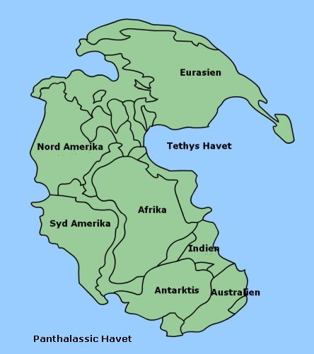
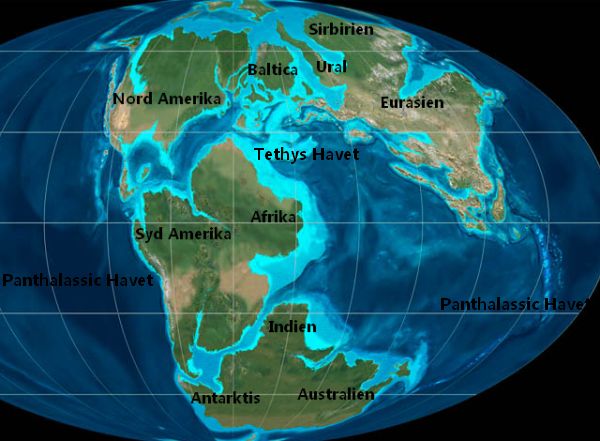
Pangaea was shaped like a C, the bay on the right side of the C is called the Tethys Sea, and the rest of the world's ocean is called the
Panthalassic Sea. The Mediterranean, Black Sea, Caspian Sea, Aral Sea, The Red Sea and the Persian Gulf are today the last remnants of The Tethys Sea.
The name Pangaea is derived from the Latin "pan" meaning that something is
all inclusive and the Greek "Gaia" that is a name for the Earth, Thus Pangaea means "the whole earth". It was formed in the Permian, but already in the Triassic, it began to fracture, which is the process that has formed Earth's existing continents and their present location.
Pangaea was characterized by extreme climate variations because it was such a huge continent. The coastal areas near Equator had a monsoon climate with summer rain, while its interior areas were dry and desert-like.
The interior of Eurasia today; for example, Chinas western Xin-Jiang province or Mongolia has a typical continental climate. The summers are incredibly hot with temperatures of 40 degrees or more, and winters are icy cold with double digits minus temperatures. The reason is that Eurasia is such a big continent, with a long distance from its interior to the water-reservoir of the ocean with its big heat content.
Pangaea was a much larger continent than Eurasia, most likely with an even more pronounced continental climate. One cannot doubt that winters in central Pangaea must have been very harsh experiences, and summers must have been insufferable glowing hot. There were no actual ice ages during Mesozoic.
A team of researchers from the U.S. Brown University has produced a climate description of Pangaea in the Triassic period using samples taken from the seabed of lakes from Nova Scotia to Georgia. They came to the conclusion that Pangaea's summer temperature in Triassic was 20 degrees warmer than today, and the atmospheric concentration of CO2 was five to twenty times greater than today.
|
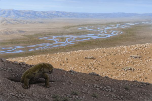
Reconstructed Pangaea landscape from the Triassic - Painted by Mauricio Anton.
The monsoon is a steady wind blowing from sea to land or from land to sea due to temperature differences between land and sea.
The sun heats both land and sea in the summertime, but the temperature of forests, deserts and steppes rises faster than the temperature of the sea by the same solar radiation. Rocks and soil have a poor thermal conductivity and little heat capacity, and therefore, the temperature rises quickly on land; water, however, can absorb much more heat from the same solar radiation with less rise in temperature, because water has a high thermal conductivity and high specific heat capacity, and additionally the heat will quickly be distributed to deeper layer in the ocean by waves and currents.
When land masses are heated in the summertime, warm air rises to the sky creating a low pressure over land. Warm moist air from over the ocean will flow in and try to fill out this low pressure, and that wind is the monsoon. In winter sea may be warmer than land, and then the monsoon blows from land to sea.
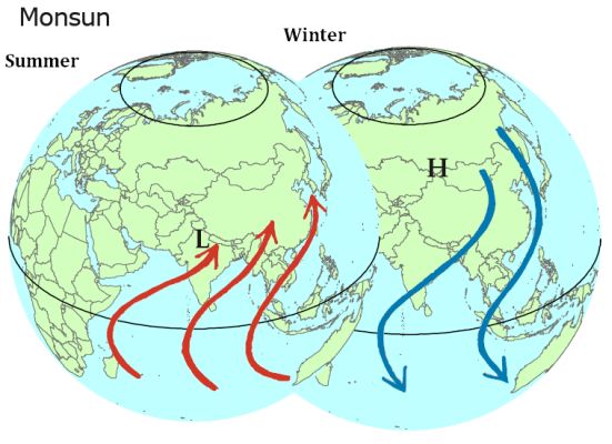
The modern Southeast Asian monsoon - In principle, there may be monsoon winds
everywhere, where land meets sea. However, the Southeast-Asian monsoon is the
best known, because here a very large continent meets a very large and hot
ocean. Pangaea was an even larger continent that bordered on an even larger ocean, which must have been the cause of even stronger monsoon winds.
The larger land masses that border to larger oceans, the more pronounced will the monsoon wind be. In principles, there can be monsoon winds all over the world, but presently the East Asian monsoon is the most famous because here a very big continent is bordering a great and warm sea.
Pangaea was the largest continent ever, and it was surrounded by an equally huge ocean that was the Panthalassic Sea, which covered the rest of Earth's surface. It is believed that the shores of Pangaea must have been exposed to very strong monsoon winds.
Today the tendency is that the interior of the world's continents becomes still more dry and desert-like. Sahara and Kalahari can be found in Africa's interior, Gobi and Taklamakan exist in the heart of Asia, and the Great Sandy Desert takes up the interior of Australian. Pangaea was a bigger and more massive continent, and therefore one must imagine that the supercontinent's interior in even greater extent must have been covered by endless, barren and windswept deserts.
In Pangaea's northern part were forests that consisted of various conifers.
When a damp wind blows from the sea over land, it will release its humidity as rain, when it is forced over high mountains, as we today know from, for example, western Norway. But the original continents, which constituted the Triassic continent Pangaea, were still largely flat as pancakes. There were only a few and low mountains, such as the Cambrian Mountains and the Ural Mountains, and therefore one must assume that the winds from the sea not to the same extent were forced to release their rain. Hence one must think that in Pangaea very large areas were covered with desert and dry steppe. Around equator have been found signs of smaller areas with tropical vegetation.
Sediments generated by evaporation of water is very common in layers from the Triassic. They can have been formed by lagoons having been isolated from the sea due to the formation of sandbars, then they simply dried out in the arid
climate. Inland Lakes may show several layers of sediments formed by evaporation, the lakes seem to have dried out several times.
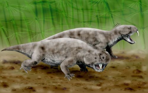
Reconstruction of Hyperodapedon that was a kind of Rhynchosaur.
In Ischigualsto in Argentina, near the border of Chile, important discoveries have been made from the Triassic period. Giant fossilized tree trunks that have been named, Protojuniperoxylon ischigualastianus, more than 40 meters high, bear witness to a rich vegetation at this location. Also, fossil ferns and horsetails have been found.
Perhaps surprisingly dinosaurs are, neither the most numerous or the biggest group of species of animals from Ischigualasto. Only about 6% of all four-legged animals, which are found there, are dinosaurs. Fossilized bones from Rhyncosaurs and Cynodonts are far more common. This shows that dinosaurs were not an immediate success when they first appeared in the Triassic.
Rhynchosaurs from Triassic are found all over the world. They were stocky herbivores with short legs and a sharp beak. The lower jaw was deep, and when they closed their mouth the upper jaw clamped down in the lower jaw as the blade of a folding knife is pressed into the handle. This scissor-like movement did probably enable Rhynchosaurs to cut tough plant material. They were generally rather small, however individual species could be up to two meters
long.
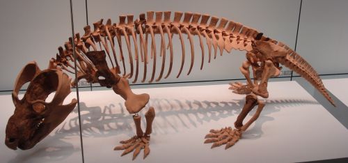
Reconstructed skeleton of Cynodontis Belesodon Magnificus in "Staatliches Museum für Naturkunde Stuttgart". Cyno-dont means canine(dog) tooth.
Cynodonts had almost all mammalian characteristics. Their teeth were fully separated, their skull buckled out in the back of the head, and it is said that many of them could stand in an upright position. Like probably all other Mesozoic proto-mammals cynodonts did still lay eggs. It is assumed that they were warm-blooded and covered in hair. Some Cynodonts species could be a meter long.
Pangaea began breaking up at the end of the Triassic. Between North America and Africa, volcanoes were spewing out large amounts of alkaline lava, which can be found on both continents. It is assumed that this volcano disaster initiated another round of extinction of up to 80% of Earth's species, and thus paved the way for the dinosaurs that came to dominate the Earth in the next hundred million years.
Jurassic began 213 million years ago and lasted until 144 million years before present, a total of 69 million years.
|
World in Jurassic - Pangaea has disintegrated. Foto scotese.com-
The gradual break-up of Pangaea that began in the late Triassic, continued in Jurassic. The climate of the new and smaller continents was milder and more rainy. Hot and humid tropical breezes blew through dense forests of ferns, cycads, ginkgo trees and various conifers.
Since large parts of the Earth's surface were covered by water and green plants,
planet's albedo decreased, and more of the Sun's energy was absorbed as heat. The increased atmospheric moisture content also helped to increase the temperature, because water vapor is a strong greenhouse gas.
The fact that many ferns and gymnosperms plants are known from both polar regions indicates that the climate of Jurassic was generally hot and without big geographical variations. Fern species, whose modern relatives do not tolerate cold, were widespread also at higher latitudes. Some Russian researchers believe that the fauna found indicates that winter temperature in
Siberia never fell below freezing. Fossils of crocodile-like lizards, whose modern relatives can only live in subtropical or tropical regions, have been found in Greenland, which also confirms that the climate was warm and humid almost all over the globe.
Petrified tree trunks from the Jurassic at Curio Bay in New Zealand.
Coral reefs from the Jurassic have been found on the Sakhalin Peninsula at 60 degrees northern latitude, which is 30 degrees farther north, than where today's coral reefs are found. Coral reefs require a minimum temperature of 20 degrees in order to grow.
Discovery of coal all over the globe, formed in the Jurassic period, also supports the theory of the hot and humid climate almost across the Earth.
However, in a belt around the equator that spans between 10-20 degrees north and south of equator, one can find layers of gypsum, and salts deriving from dried-up lakes and gulfs isolated from the sea due to the formation of sand bars; that demonstrates a rather dry climate in this area. "Lower Jurassic Navajo Sandstone" in south-western Utah also testifies a dry windy climate with a landscape of sand dunes, where the barren dryness was interrupted only by heavy monsoon rain in the summer.
In Jurassic the disintegration of the supercontinent Pangaea continued. Laurasia, the northern half, divided into North America and Eurasia. Gondwana, the southern half, began to break up in the mid-Jurassic. The eastern part, which consisted of Antarctica, Madagascar, India and Australia, was torn from the western part, which was Africa and South America. New oceans flooded the spaces between the new continents. Mountains rose up from the ocean floor and pushed the World Ocean's sea surface level higher.
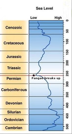
Global sea levels in the Phanerozoic. As it can be seen, there are various opinions about when Pangaea began to break up.
During the Jurassic sea surface level increased and large low-lying areas were flooded. At first thought, we will connect a rise in world's sea surface level with melting of ice caps at the poles. Perhaps there have been minor ice caps in southern Pangaea, without the existence of an actual ice age, as we have today with the huge ice sheets in Greenland and Antarctica. These small glaciers can have melted during the Jurassic and thus in the short term - a few million years - contributed to the increased sea surface. But this alone can not explain the rise in world's sea surface level in Jurassic.
Not all changes in the world's ocean surface levels are connected to the formation or degradation of polar ice caps. Other, more long-termed - several hundred million years - mechanisms, have been suggested as causes of change in World's sea surface level.
The total volumen of water on Earth must have been fairly constant over the last four billion years. Really long-term changes in sea surface levels - for example, over hundred million years - must have been caused by changes in volume and shape of the marine basin caused by plate tectonic activity.
When a supercontinent is formed, some tectonic plates will be pushed down under other plates and thereby reduce the volume of land compared to the volume of the "water tank", and thus make the sea surface level in the ocean to decrease. For example, it is believed that the fact that the Indian subcontinent through the last 50 million years has been pushing down under the Asian plate, thereby creating the Himalayas and the Tibetan plateau, has been the cause of a reduction in sea surface level of about 70 m during these 50 million years - ceteris paribus.
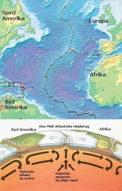
The formation of the mid-Atlantic ridge.
Conversely, when a large continent is divided into several smaller, the length of the total coastline is increased. The volume of continental shelves along the coastline, which previously had been pressed under some other continent, will thus also increase, and the amount of seawater, which is hereby displaced, will cause increased sea surface level. It is believed, for example, that the division of Pangaea into smaller continents have been the cause of an increase in sea surface level of 100 m. during the last 200 million years.
When two tectonic plates move apart, it will cause volcanic activity, related production of lava and following formation of volcanic rocks, which will displace sea water and thus also be a cause of rising sea surface level in the world's oceans.
Thus, North and South America and Europe and Africa have over the last two hundred million years moved away from each other at a rate of 2.5 cm. annually. The Mid-Atlantic Ridge is an underwater mountain range that is created by such
volcanic process. The increasing volume of this mountain range is displacing seawater and causes - ceteris paribus - an increase in world's sea surface level.
The Mid-Atlantic ridge extends from Antarctica to Jan Mayen. Azores, Iceland, Jan Mayen and Saint Peter and Paul Rocks off Brazil are all created by volcanic activity connected with the creation of this underwater mountain range.
We should consider that when both land masses and the bottom of the World Ocean are changing, it's hard to comment on exactly how many meters, the sea surface level has gone up or down. A true precision would imply that somewhere we have a fixed and unchanging scale that measured the distance from the surface of the sea to Earth's center or the like; and that we do not have.
But in any case, there is strong evidence that the sea surface level in the World increased during the Jurassic, which meant that many low-lying areas were
transformed into shallow coastal sea, and in the same time the climate became more oceanic, that is wetter, warmer and with much less seasonal variation.
|
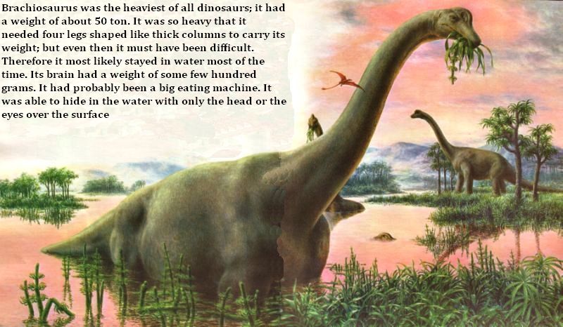
Brachiosaurus.
There are data that indicate a shorter period of intense heat, about 183 million years before present (Uriarte). Some scientists imagine that underwater
landslides have caused emissions of the powerful greenhouse gas methane from the coastal seabed, which increased the temperature significantly. They have found indications of this in the form of two meters thick sediments with very little content of carbon-13 that they think is a typical indication of methane
(Hesselbo).
On land, the picture was totally dominated by the dinosaurs. The herbivorous
sauropod Brachiosaurus for example, could be up to 16 m. high and 26 m. long and reach a weight of more than 50 ton. Another sauropod, which has been named Diplodocus, could be 27 meters long. The sheer size of these giants might have
protected them from attack by the predatory dinosaur Allosaurus.
Modern gardeners can make their plants grow faster by increasing the CO2
content in the greenhouse atmosphere. In Jurassic, the atmospheric CO2 level was
5-8 times higher than in modern time, and this can explain how the fauna could
produce sufficient biomass to feed such giant creatures.
There are different opinions about whether dinosaurs were cold- or warm-blooded. If the birds are their descendants, they were warm-blooded. But it is also possible to imagine that cold-blooded dinosaurs were feeding in the hot and humid daytime, while small warm-blooded animals were rustling in the undergrowth at night.
|
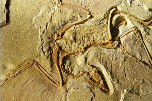
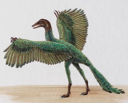
Top: Fossils of Archaeopteryx Lithographica as found at Solnhofen in
Germany.
Bottom: Reconstruction of Archaeopteryx lithographica.
In Jurassic birds began to compete with flying reptiles, the pterosaurs, on the airspace. The earliest known bird is Archaeopteryx Lithographica, which is found in limestone from Jurassic near Solnhofen, Germany.
Archaeopteryx was of the size of a crow with short, broad wings and a long tail. It had wings and feathers like modern birds, but also many features in common with dinosaurs, for example, jaws with sharp teeth, three fingers, which ended in crumb claws, a head covered with scales and a long bony tail. It gives many indications that birds descend from dinosaurs.
The dinosaurs and the birds have several common characteristics, which provide arguments that the birds are descended from the dinosaurs. These are the porous air-filled bones, the typical bone that we call the "wishbone", they have the three toes and a "spur" on the "hind legs" in common, it has been shown that many dinosaurs had feathers - like the birds, both birds and dinosaurs reproduce by laying eggs.
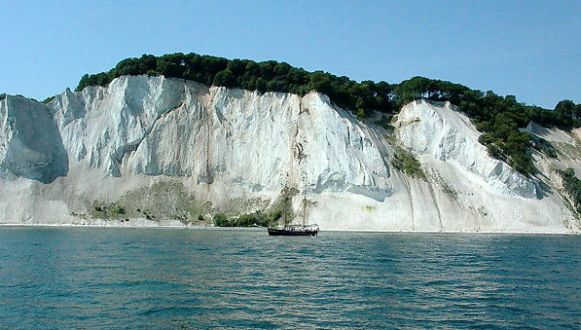
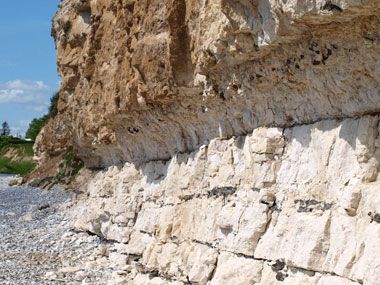
Møns Klint in Denmark - millions of small shellfish lived in the Cretaceous sea, died and sank to the bottom, forming the huge chalk layers.
The Cretaceous period began 145 million years ago and lasted until the dinosaur extinction 65 million years ago. During this period prevailed almost everywhere on Earth a warm and humid climate. The thick layer of chalk, which was created by the microscopic calcareous algae that have been found in abundance throughout the Earth's oceans, gave its name to the period. Up until then, chalk deposits had been restricted to shallow coastal waters.
By the middle of the Cretaceous period about 100 million years ago, the mean-
temperature on the planet's surface was between 6 and 12 degrees higher than it is today. The annual mean temperature in the Arctic was about 10 degrees,
which is about 20 degrees warmer than today. In the tropical regions, the surface water temperature was approx. 5 to 10 degrees higher than the present.

|
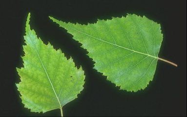
Left: Lilac has smooth-margined leaves.
Right: Birch is not smooth-margined. Smooth-margined leaves on indigenous trees in Denmark is very rare.
The Americans Irving Bailey and Edmund Sinnott observed in 1915 that there is a
correlation between the number of plant species with smooth-margined leaves in an area and the climate of this area. Then showed the American geologist Jack Wolfe, that this more specifically means a connection between the percentage of leaves with smooth margins and the mean annual temperature of this area.
Scientists have collected a large number of different leaves from native forests all over the Earth, and established a correlation between the distribution of leaf types and the mean temperature of the area; the uncertainty is plus or minus 4-6 degrees depending on how many kinds of leaves that have been collected.
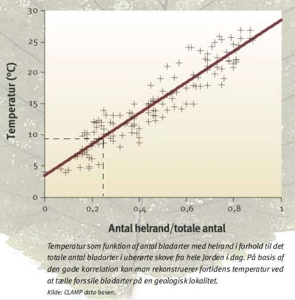
Temperature as a function of the proportion of smooth-margined leaves - From 2006 Geoviden - Geologi og Geografi nr. 4, see link below.
This relation can also be applied to fossil leaves. Over several years Danish geologists have found fossil leaves representing 87 different plant species from the Cretaceous period on the Disko Island off the west coast of Greenland. Of these, 20 species have smooth-margined leaves, and the rest have not. That is 23% smooth-margined. Then the graph tells us that the annual mean temperature in Western Greenland in Cretaceous must have been about 9 degrees. In modern time the mean annual temperature on Disko Island fluctuates between -2 and -9. degrees. The modern Danish mean annual temperature is 8 degrees. So in Cretaceous, it was warmer on Disko Island than in today's Northern Europe.
Analyses of fossil leaves from the Cretaceous era found in northern Alaska and
Russia shows that the annual mean temperatures in these areas fluctuated between 9 and 12 degrees, and the coldest month had a mean temperature of about plus 5 degrees, which fits very well with the findings from Greenland.
However, there are also other methods to estimate past temperatures.
There are two oxygen isotopes, namely, oxygen-16 and oxygen-18. Almost all oxygen atoms on Earth have 8 protons and 8 neutrons and thus an atomic weight of 16. However, 0.2% of the oxygen atoms have 10 neutrons and thus an atomic weight of 18. Water molecules containing oxygen-16 evaporates easier than water with the heavier oxygen-18, thus an increased relative content of oxygen-16 in a sample can indicate evaporation and consequently warm climate.
In a warm period evaporated water will fall as rain or snow over land and rather fast find its way back to the sea through the rivers so that the sea retains its original isotope distribution.
But in a cold period, some of the evaporated water will fall as snow on
glaciers and ice caps and remain there, and therefore glacier-ice will be poor in oxygen-18, while seawater will be will be equivalent rich in oxygen-18.
In the Cretaceous oceans lived a lot of microscopic algae that had a shell of chalk. When they died, they sank to the bottom of the ocean, where their shells still can be found. The shells contain the relative frequency of oxygen isotopes of the time, the algae lived. Scientists can analyze the microscopic shells and in this way get an indication of the temperature of the Cretaceous ocean.
|
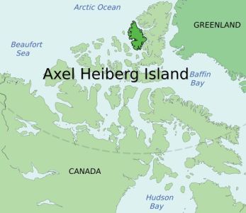
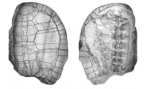
Left: Axel Heiberg Island.
Right: Fossil of turtle from the Cretaceous found on Axel Heiberg Island. The turtle is named Borealochelys axelheibergensis. On the same location were
found fossils from the dinosaur Plesiosaur and the crocodile Champsosaurus.
The Danish "Cretaceous Research Centre" under the Department of "Geologisk Institut" has sampled the white cliffs, Stevns Klint, and determined Cretaceous sea temperature to have been 14-22 degrees, which is much higher than today's. Present day Danish sea temperature only in summertime reaches 16 degrees.
|
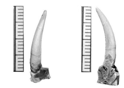
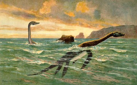
Left: Teeth from Plesiosaur found on Axel Heiberg Island. The scale is in
cm.
Right: Plesiosaurs painted by Heinrich Harder.
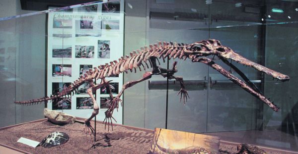
Animals and plants that today are typical of a warm climate, such as crocodile-like animals, were in Cretaceous able to live on very high latitudes. Discovery of fossils of a million years old trees, sea turtles and the
crocodile-like Champsosaurus on Axel Heiberg Island in northernmost Canada is an even stronger indication that it really was very hot in the Cretaceous era, as today's crocodiles prefer water temperatures between 25 and 35 degrees.
|
On Axel Heiberg Island scientists also found fossils of the crocodile-like
Champsosaurus.
Layers from Greenland have been found to contain fossils of leaves from breadfruit tree, a plant that today only grows in a humid tropical climate.
Coal is formed in a hot and humid climate, and there are coal deposits from
Cretaceous all over the world at all latitudes, this indicates that it was really very hot all over the Globe. The large surface-deposits, which today are being exploited in the western United States, have been formed in Cretaceous.
Formation of bauxite requires a warm tropical climate with regular seasonal
precipitation, and bauxite from the Cretaceous has been found also at relatively high latitudes, among others in Greenland. Again suggesting that a hot and humid climate dominated almost everywhere on Earth.
In the Cretaceous period was the concentration of CO2 in the atmosphere without any doubt many times higher than today's 400 ppm.
Flowering plants reach their maximum photosynthetic efficiency at a CO2 level between 1,000 and 1,500 ppm. Precisely in Cretaceous flowering plants had their
peak, which makes it very likely that the CO2 level really was high.
The determination of CO2 content in the atmosphere of the past can be carried out in two ways. With the stomata method the scientists will analysis fossilized leaves, Alternately the content of the carbon-13 isotope in findings can be determined, as it indicates CO2.
|
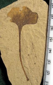
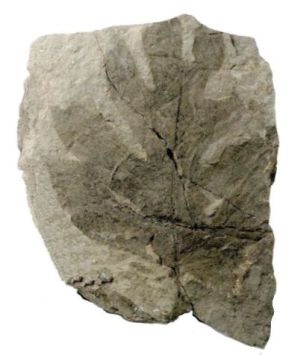
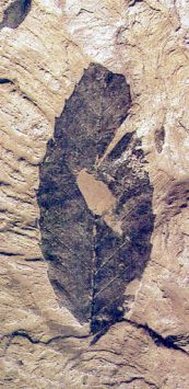
Left: Petrified ginkgo leaf from Cretaceous.
Mid: A Petrified leaf from breadfruit tree found in Greenland.
p
Right: A petrified leaf from Cretaceous that resembles a leaf from beech.
Trees absorb CO2 for their photosynthesis through slot openings on the underside of the leaves, which is called stomata. Pressed and dried leaves, collected from old herbariums of the last two centuries, seem to indicate a decrease in the number of stomata openings on the underside of leaves in recent time, where the CO2 content in the atmosphere, as you well know, has increased a bit. Therefore, it is assumed that the number of stomata openings is inversely proportional to the atmospheric CO2, as trees seek to minimize the necessary number of openings to restrict evaporation.
Thus the stomata procedure is to analyze leaves or fossils of leaves and find the density of the stomata opening on the underside of leaves.
The density of the stomata openings on fossil leaves from ginkgo shows that the CO2 concentration in the Cretaceous atmosphere was 4-5 times and sometimes up to 7 times as big as today.
|
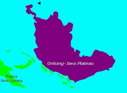
Left: The Ontong Java Plateau is a huge oceanic plateau of volcanic origin from Cretaceous located in the Pacific Ocean, lying north of the Solomon Islands. The plateau covers an area of about 2,000,000 km2, or roughly the size of Alaska, and have a thickness of several kilometers.
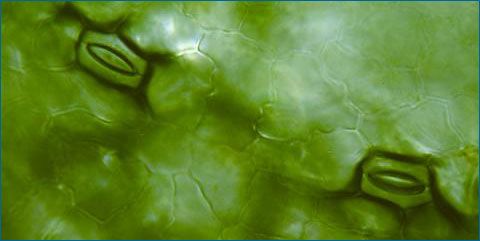
Right: Microscopic stomata openings on a leaf from duckweed.
Another method to determine the CO2 content in the atmosphere of the past is to analyze the content of carbon-13 isotope in layers from this time, as the level of carbon-13 is dependent on atmospheric CO2.
Cretaceous high atmospheric CO2 concentration was created by emissions from volcanic cracks in the ocean floor in connection with that the continental plates, which had constituted Pangaea, began to move away from each other. A process that started already in late Triassic. The Caribbean islands in the Atlantic Ocean, the Kerguelen Islands in the southern Indian Ocean and the underwater Ontong Java plateau near the Solomon Islands in the Pacific are all large oceanic basalt plateaus, which have been created by volcanic eruptions in mid-Cretaceous.
|
Fossilized bones from the Sauropod Argentinosaurus are found in Argentina in South America. The animal is assumed to have been 40 meters high with a weight up to 75-80 ton, it is said. In any case, it has been a true gigantic animal. As you can see, its brain is quite small, it has probably been a huge eating machine that walked around in lakes and coastal waters. One must believe that the high CO2 content in the atmosphere has enabled the growth of all the biomass needed to feed those giants.
Some of the dinosaurs had a simply enormous size. Experts believe that the
existence of these giant animals was only possible because of an abundance of
biomass, created by a hot and humid climate and a high CO2 content the atmosphere.
The reason for a possible large greenhouse effect during the period must not only be attributed to the relatively large CO2 content of the atmosphere. A big content of atmospheric water vapor probably played an even more important role.
Today, the water vapor's contribution to the atmospheric greenhouse effect is limited to tropical and subtropical regions. Because of the cold, the absolute humidity on higher latitudes is very low; for example, the water vapor content of the air in winter in Antarctica is about 0.00001%, while humid areas at the equator can have an absolute humidity of up to 4%.
|
Reconstructed Map of the World in the Cretaceous - Europe was an archipelago and the West Siberian plain and the Mississippi Valley was shallow seas that created a connection between the Arctic Ocean and the oceans of the world. Also, North Africa was flooded. Foto scotese.com.
In Jurassic and Cretaceous, the air at the poles was much warmer than today, and its absolute humidity was therefore much higher, and consequently, the
water-vapor's contribution to the greenhouse effect was also considerably higher.
An important geographical cause of the hot and humid climate of the time was the distribution of sea and land masses. The breakup of Pangaea into still smaller continents favored a mild oceanic climate that was very different from the harsh continental climate, which prevailed in the Triassic period's Pangaea.
Compared with the Triassic, 20% of existing land masses became flooded by sea during Jurassic and Cretaceous and converted into shallow coastal areas. Many
areas of Eurasia and Africa became flooded by the Tethys sea. Europe was an archipelago in the Tethys sea. The West Siberian Lowland and Mississippi Valley was shallow seas, which created a connection to the Arctic Ocean.
It is assumed that deep-sea temperature in the Cretaceous was 15 degrees, which is of course somewhat higher than the 2 degrees that can be measured today.
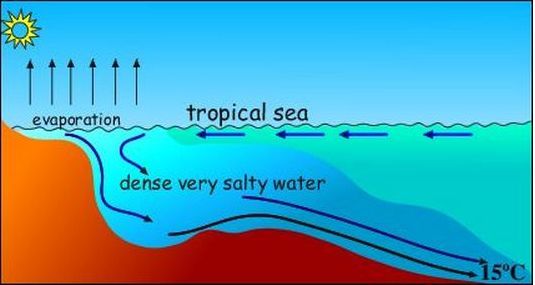
It is assumed that in Cretaceous deep-sea water was hot. In the shallow coastal waters, that was very widespread in this period, large amounts of water vaporized making remaining water more saline and thus heavier. The hot, saline and heavy water sank to the bottom and sought to the deep sea as a warm
bottom current.
Today, deep sea water comes from the Arctic seas, where it is cooled and thus becomes relative heavy, it sinks to the bottom and then flows away from the north and south seas as cold bottom currents. However, it is assumed that in Cretaceous the deep sea water currents came from shallow coastal tropical waters. The evaporation in these waters meant that salinity increased; this made the water relatively heavy, and the heated salt water sank to the bottom and flowed out into the deep seas as warm bottom currents.
A very similar process takes place in the Gibraltar Strait today, when heated
salty water flows out into the world's oceans along the bottom, while colder and less salty water flows into the Mediterranean Sea as a surface current.
The Cretaceous Tertiary boundary is evident in Stevns Klint in Denmark, it contains the so-called fish clay containing iridium from outer space. Nowhere else in the world the Cretaceous Tertiary boundary is so well exposed and easy to study. Therefore, Stevns Klint today is a candidate for UNESCO World Heritage.
During the last part of Cretaceous from about 80 million to 65 million years before present, the CO2 content in the atmosphere decreased back to about twice today's level. This happened while the sea surface level in the World's oceans dropped. The temperature declined, but not so much that ice was formed at the poles. The Polar Sea was still ice-free - at least in the summer - and the temperature in Greenland, Alaska and Antarctica was still considerably higher than today's.
At the end of the period occurred the K-T disaster (Cretaceous-Tertiary, as it is named after the German Kreide-Tertiar), which was a mass extinction of a big
variety of species that had hitherto dominated life in the sea as well as on
land. Ammonites, which had lived in the oceans since Devon, disappeared in one blow together with many kinds of plankton. All the dinosaur species on land
became extinct.
|
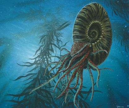
Reconstruction of an ammonite, an animal that had lived in the oceans of the Earth through hundreds of millions years. They disappeared at the K-T Disaster along with the planktons, which were their food. Ammonites were distant relatives of contemporary squids that swam around with a kind of snail-like shell.
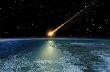
Right: The K-T Disaster 65 million years before present
Some believe the extinction was rapid, a maximum of a few thousand years, while others believe that the extinction of the many species occurred gradually and
started several million years before the end of Cretaceous.
Most who believe in the rapid extinction process, support the theory that Earth was hit by a huge meteor with a diameter of about 10 km. that struck down in the shallow waters off the Yucatan peninsula near a place called Chicxulub in Mexico, where it created a crater with a diameter of about 180 km. In connection with the impact, a thin layer of iridium from outer space was scattered throughout the globe. This thin layer has really been found all over Earth in layers from the transition from Cretaceous to Tertiary and marks the end of Mesozoic.
|
Fortidens Drivhusverden:
Geoviden - Geologi og Geografi Nr. 4 (pdf) Indsigt for fremtiden Evolution of Rotation Structures in the Earth's Geological History Victor Zemtsov - Institute of Geology, Karelian Research Centre, RAS, Russian Federation. Paleomap Project - Christopher R. Scotese The goal of the PALEOMAP Project is to illustrate the plate tectonic development of the ocean basins and continents. Pangaea animation fra Wikipedia SEA LEVEL VARIATIONS OVER GEOLOGIC TIME - pdf M. A. Kominz, Western Michigan University, Kalamazoo, MI, USA. Pangaea Animation by Edgar Salmingo. Earth's Climate History (Kindle Edition) by Anton Uriarte. |
| To start |